
EPW026152 ENGLAND (1929) [Unlocated]. UNLOCATED
© Copyright OpenStreetMap contributors and licensed by the OpenStreetMap Foundation. 2024. Cartography is licensed as CC BY-SA.
Nearby Images (48)
EPW000143

EPW000667

EPW005260

EPW006389
, 1921")
EPW007181

EPW015853

EPW015854

EPW015855

EPW016012

EPW016510

EPW016641

EPW017028

EPW017029

EPW017136

SAW003585

SAW003586

SAW009337

SAW009800

SAW009801

SAW009802

SAW010734

SAW014737

SAW017926

SAW017927

SAW032504

SPW020275

SPW020280

SPW020281

SPW020284

SPW020632

SPW020633

SPW027083

SPW049776

SPW049777

SPW049779

SPW049783

SPW049791

SPW049798

SPW049801

SPW049827

SPW049828

SPW049831

SPW049832

SPW049834

SPW049948

SPW049949

SPW051009

SPW062638

Details
| Title | [EPW026152] UNLOCATED |
| Reference | EPW026152 |
| Date | April-1929 |
| Link | |
| Place name | |
| Parish | |
| District | |
| Country | ENGLAND |
| Easting / Northing | 0, 0 |
| Longitude / Latitude | -7.556448482059, 49.766185796754 |
| National Grid Reference | SV000000 |
Pins
 Phil |
Monday 15th of February 2016 11:15:06 PM | |
adfbristol |
Wednesday 26th of June 2013 01:18:49 PM |
User Comment Contributions
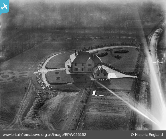
Ref EPW026152 Date April 1929 The case for considering this location;- Prince Consort Drive, Ascot Google Maps Ref ; 51.404076, -0.698382 This location is 600 metres due south from the centre of Englemere pond. The main stand at Ascot racecourse is 1500 metres to the North East for added location. Why is this the only house on the road that is facing SSW when all the others face SW? I think that it is because it was the first house to be built. The plots around being sold off gradually Over the years. The newer houses all conform to being parallel to the NW–SE direction of the road. I have not got maps of the correct scale and period to check but either the road has been straightened at sometime Or the curve might be due to a lens distortion… I favour the former. Any one live nearby to knock on the door and see if there is anything in the owners deeds? I am sure they would love to have a copy of the photograph if it is their house. The original picture shows woodland which is pretty bare for an April photograph but this woodland, now quite mature, is pretty much in evidence on Google. The Google maps reference lands you on the drive that is nearest to you in the 1929 picture. The angle of the drive to the right as you drive in, is the same today as it is in the 1929 picture. The drive to the top of the picture beyond the house is now the entry to the next house beyond. Since the late 1920’s when this house was built it has probably been subject to at least a couple of major upgrades, but the basics are still there. The garage block has lost it’s small dormer window but it would be cheaper to re-roof it in that simpler fashion. The roof on the house in the picture looks to be a four-pitch roof with a central well which not only increases the tile area and creates the potential for water ingress problems that are difficult to access in the centre of the house it also wastes the extra valuable floor space. Again when re roofing this it would be cheaper to do it as per the modern house with an overall four pitch roof which is what I believe has happened. At the same time as doing this the gable end facing us in the original picture has been removed to simplify the roof structure on that elevation. The front of the house has been altered, there no longer being a projection of the elevation nearest to us out in front of the house ie; to the right in the picture. The front elevation now runs the whole of the front width of the house so that front is now aligned with the ridge of the garage. This would simplify the roof construction and therefore its cost whilst adding extra living space, the usual reason for major works. Having searched the rest of the area pretty thoroughly this is the only property I can find with the relevant orientation to a road and to the compass direction. The developments I have listed are all likely and feasible and are based on my knowledge of housing development. If the property shown in the picture is still in existence I believe this is the most likely candidate in this area. |
Phil |
Monday 17th of October 2016 01:43:19 AM |
Hi Phil this is really good work but sadly I don't think it's the right spot. The National Library of Scotland has free online historic maps including high-definition 25inch to the mile ones of the Ascot area - the 1932-5 map shows the Prince Consort Drive area completely undeveloped (just woodland, no houses) and with no curve in the line of the track/lane that later became the road. I tried pasting a screen shot here but I can't so here's the relevant map url maps.nls.uk/view/104198221 |
adfbristol |
Monday 17th of October 2016 01:43:19 AM |
OK if this is anywhere near Englemere House, and from the same flight, then it was probably taken within a short time of the Englemere shots. The sun is almost due West of Englemere House, so those shots were taken mid-late afternoon. If this shot was indeed taken within a short time, then this house faces roughly due west, with the road to its north running east-west and bearing away slightly northward at the curve. (I know that's a lot of ifs, but it's a start - but it may not be correct.) This is borne out a little by the orientation of the house... west facing entrance front, the utilitarian side with garage doors facing north, rear of the house facing east to get the morning sun in kitchen and breakfast room, and the facade opening onto formal gardens oriented due south. That would be a fairly standard arrangement for a house at this time. In terms of architecture, I think the label Arts and Crafts may have been a little misleading. It's from that stable but probably 'sub-Arts and Crafts'. A built-in garage for a house of this size means it's almost certainly post-1920, and the marks on the garden and piles of rock suggest the landscaping is very new. So it may be a house of a few years old at maximum. The general bareness and small trees lining the drive support that idea. |
adfbristol |
Wednesday 26th of June 2013 12:38:23 PM |
Katy, Thanks for the additional information on the flights. The pine trees on relatively flat land in the smudgy background are perhaps the most important locational pointer. This would clearly point to the Surrey heathland - Sunningdale in terms of the flights suggested. This increasingly fragmented area of heathland stretches from Dorset, Hampshire (New Forest) in Surrey and Sussex (Ashdown Forest). However, there is not a lot of this type of territory around Hastings.... unless they caught a house on the way back from Hastings. It does on look quite right for Ashdown Forest, but that is a purely subjective comment. Other areas of heath include parts of Suffolk and Norfolk around the Brecklands. Liverpool is outside the distribution of this type of natural vegetation in the UK. Arts and Crafts House it may be .... but it is not an Edwin Lutyens house. |
 Maurice |
Wednesday 30th of January 2013 09:23:58 AM |
Additional thought ... the earth work in the front of the picture would be about the right size for a tennis court and appears to include heaps of earth on the down grade side ready for levelling ... there is a nice set of steps in place already for, "anyone for tennis". I have also trawled the web for references to Art and Crafts houses in Ascot ... nothing that fits. |
Maurice |
Monday 28th of January 2013 05:29:04 PM |
Hi Maurice, Unfortunately we don't have a better date than April 1929 for this image. Other Aerofilms Ltd Register entries around this one include targets in Liverpool on 18 April, Sunningdale on 19 April, Hanworth Air Park on 22 April and Hastings on 24 April. I guess the south-east is more likely than the north-west? Yours, Katy Britain from Above Cataloguing Team Leader |
Katy Whitaker |
Monday 28th of January 2013 05:29:04 PM |
Having just spent 30 mins wondering around the modern images of Ascot area I must abandon the attempt to find a match. Defining features would seem to be the bend in the road (relative easy to pick up from any orientation), the square of internal roof over the centre of the building (there are a lot of large houses in Ascot with central flat roofs but I could not see one like this), the slope of the garden and the steps are less likely to have changed than other landscape features and the curve of the drive would probably still be the same although it could be well hidden by the trees. Looking for more than about four variables at a time is probably counter productive. The edge of the forest (which looks as if it has been burnt in the original picture) may well have moved as additional houses were built as indeed the character of the ground in front of the house, where the marks on the earth might suggest further building or is this just yet more landscaping. While this might seem to be a large house in 1929, I suspect that it would be somewhat middle sized for Ascot today. However it has bigger grounds than many more modern houses in the area. |
Maurice |
Monday 28th of January 2013 02:52:01 PM |
For the avoidance of doubt am I correct in saying that we do not have a location for this one at present? We suspect that it is in the Ascot area but we have no evidence of it's exact location. |
 Class31 |
Monday 28th of January 2013 01:41:56 PM |
That's right Class31. Katy |
Katy Whitaker |
Monday 28th of January 2013 01:41:56 PM |
I think this belongs to the set EPW026141 - EPW026151 which immediately precede this photo, also taken in April 1929 and in a similar looking area (very wooded, lots of deciduous trees without leaves) and with the same long, late afternoon shadows to the east. That would make the location for this somewhere around Englemere House, Ascot. |
Rebecca |
Monday 28th of January 2013 12:37:42 PM |
Hi Rebecca Thanks for the spot. I have passed your comments onto our Cataloguing team to investigate. They will in due course update the website as appropriate. Kind regards Liz (Britain from Above) |
Liz Fife-Faulkner |
Monday 28th of January 2013 12:20:27 PM |
Hi Rebecca, Thank you for taking a look at this image. It is likely that it shows a new property in the area of the previous 11 frames and we have of course had a look round Englemere/Ascot - but unfortunately haven't yet identified the building. Aerofilms Ltd could of course have taken a one-off image of the house en route to or from the aerodrome that they were using that day. The original Aerofilms Ltd Register entry says "dud"; not very useful! If you can provide a specific location that would be very helpful. Yours, Katy Britain from Above Cataloguing Team Leader |
Katy Whitaker |
Monday 28th of January 2013 12:37:42 PM |
From other photos in the series which were taken with the sun more or less in the west and with shadows to the east, this is looking c. west |
Rebecca |
Thursday 10th of January 2013 02:41:26 PM |
This house has an Arts and Crafts look to it, and the grounds look fairly recently landscaped - so possibly only 10-20 years old when the photo was taken? |
Rebecca |
Wednesday 9th of January 2013 10:24:35 AM |


