
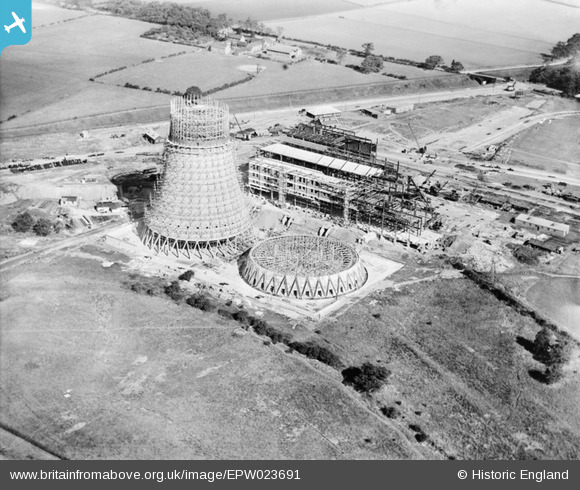
EPW023691 ENGLAND (1928). Hams Hall A Power Station under construction, Curdworth, 1928
© Copyright OpenStreetMap contributors and licensed by the OpenStreetMap Foundation. 2024. Cartography is licensed as CC BY-SA.
Nearby Images (29)
EPW023691

EPW023686

EPW023688

EPW060885

EPW023683

EPW023687

EPW023690

EAW021642

EPW060886

EPW023682

EPW023684

EPW023692

EPW023680

EPW023685

EPW023681

EPW060884

EPW060879

EPW060880

EPW060883

EPW023694

EAW021639

EAW021643

EPW060882

EAW021641

EPW060876

EPW060878

EAW021640

EPW060872

EPW060877

Details
| Title | [EPW023691] Hams Hall A Power Station under construction, Curdworth, 1928 |
| Reference | EPW023691 |
| Date | September-1928 |
| Link | |
| Place name | CURDWORTH |
| Parish | CURDWORTH |
| District | |
| Country | ENGLAND |
| Easting / Northing | 419372, 291910 |
| Longitude / Latitude | -1.7144413347884, 52.524356579462 |
| National Grid Reference | SP194919 |
Pins
Be the first to add a comment to this image!
User Comment Contributions
I think the site is usually referred to as Hams Hall. All power stations on the site have since been demolished and BMW has a plant here, with a short history on its web site - www.bmw-plant-hamshall.com/facts-figures/hams-hall-history.aspx |
 MB |
Tuesday 6th of November 2012 04:36:46 PM |


