
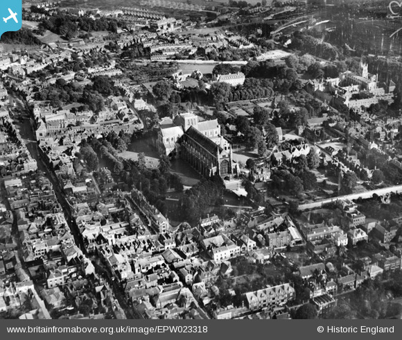
EPW023318 ENGLAND (1928). The Cathedral of the Holy Trinity and the town centre, Winchester, 1928
© Copyright OpenStreetMap contributors and licensed by the OpenStreetMap Foundation. 2024. Cartography is licensed as CC BY-SA.
Nearby Images (20)
EPW023318

EAW051299

EAW008846

EAW035271

EAW035273

EPW016870

EAW051303

EPW044868

EAW035272

EAW035274

EAW008847

EPW023325

EAW051297

EPW005114A

EAW022308

EPW016868

EAW008850

EAW051298

EAW035262

EAW035267

Details
| Title | [EPW023318] The Cathedral of the Holy Trinity and the town centre, Winchester, 1928 |
| Reference | EPW023318 |
| Date | September-1928 |
| Link | |
| Place name | WINCHESTER |
| Parish | |
| District | |
| Country | ENGLAND |
| Easting / Northing | 448166, 129297 |
| Longitude / Latitude | -1.3126144509526, 51.060454480378 |
| National Grid Reference | SU482293 |
Pins
 Class31 |
Friday 26th of September 2014 07:50:44 PM | |
Class31 |
Friday 26th of September 2014 07:48:59 PM | |
Class31 |
Friday 26th of September 2014 07:47:27 PM | |
 Alan McFaden |
Monday 11th of November 2013 10:42:59 AM |


User Comment Contributions
 Winchester Cathedral, 04/01/2016 |
Class31 |
Saturday 9th of April 2016 06:40:36 AM |


