
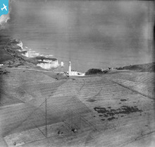
EPW023118 ENGLAND (1928). Flamborough Lighthouse and Molk Hole, Flamborough Head, from the south, 1928

© Copyright OpenStreetMap contributors and licensed by the OpenStreetMap Foundation. 2024. Cartography is licensed as CC BY-SA.
Nearby Images (6)
EPW023118

EPW023117

EAW013987

EAW013986

EPW023116

EPW039056

Details
| Title | [EPW023118] Flamborough Lighthouse and Molk Hole, Flamborough Head, from the south, 1928 |
| Reference | EPW023118 |
| Date | August-1928 |
| Link | |
| Place name | FLAMBOROUGH HEAD |
| Parish | FLAMBOROUGH |
| District | |
| Country | ENGLAND |
| Easting / Northing | 525439, 470544 |
| Longitude / Latitude | -0.0807456959064, 54.1152688408 |
| National Grid Reference | TA254705 |
Pins
 |
 Shane1 |
Saturday 21st of December 2019 01:49:42 PM |
Lynda Tubbs |
Thursday 10th of July 2014 03:06:52 PM |
User Comment Contributions
 First World War wireless station |
Lynda Tubbs |
Thursday 10th of July 2014 03:07:40 PM |


