
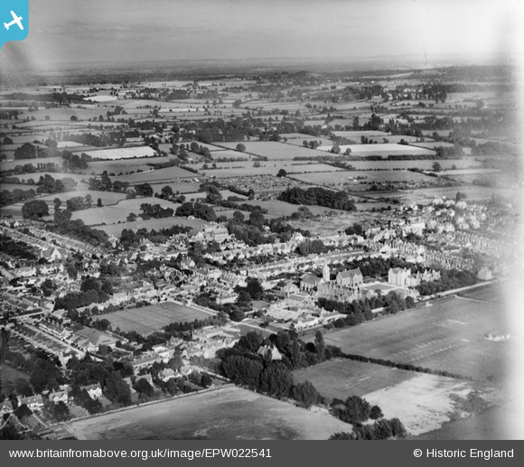
EPW022541 ENGLAND (1928). Summertown, Oxford, from the north-west, 1928
© Copyright OpenStreetMap contributors and licensed by the OpenStreetMap Foundation. 2024. Cartography is licensed as CC BY-SA.
Nearby Images (3)
EPW022541

EAW003920

EAW003919

Details
| Title | [EPW022541] Summertown, Oxford, from the north-west, 1928 |
| Reference | EPW022541 |
| Date | 11-August-1928 |
| Link | |
| Place name | OXFORD |
| Parish | |
| District | |
| Country | ENGLAND |
| Easting / Northing | 450408, 209073 |
| Longitude / Latitude | -1.269270945283, 51.777600668352 |
| National Grid Reference | SP504091 |
Pins
 ndaisley |
Friday 13th of December 2019 11:57:42 AM | |
ndaisley |
Friday 13th of December 2019 11:53:05 AM | |
ndaisley |
Friday 13th of December 2019 11:51:04 AM | |
MikeBellew |
Monday 16th of July 2012 12:17:54 PM |
User Comment Contributions
To the left of St Edwards school can be seen a rectangular open space. This is what is now Alexandra Park grass tennis courts. I think I can make out tennis courts in the photograph. |
trevorlea |
Tuesday 26th of August 2014 02:36:44 PM |
Dear Brainier and Earthenware, That’s great; we’ve reviewed your comments and thanks to your help we can update the catalogue. The revised record will appear here in due course. Hope you have the same success solving some of our other mysteries! Katy Whitaker Britain from Above Cataloguer |
Katy Whitaker |
Monday 2nd of July 2012 04:17:56 PM |
St. Edward's School, Oxford, from the northwest. Woodstock Road (foreground), Banbury Road (middle ground). NGR is correct. |
Earthenware |
Tuesday 26th of June 2012 10:24:32 AM |
This photograph is looking South East from a vantage point south of Wolvercote near Oxford. In the centre right is St. Edwards School (the quad is visible with the cross pathways in the grass and a circle in centre). The school fronts to Woodstock Road in Oxford, and the Banbury Road is the main road further back. Current view would be https://maps.google.co.uk/?ll=51.776982,-1.268749&spn=0.005377,0.013937&hnear=Oxford+OX2+7TQ,+United+Kingdom&t=h&z=17 |
Brainier |
Monday 25th of June 2012 05:20:06 PM |


