
EPW022278 ENGLAND (1928). Carson's Chocolate Factory, Siston, 1928

© Copyright OpenStreetMap contributors and licensed by the OpenStreetMap Foundation. 2024. Cartography is licensed as CC BY-SA.
Nearby Images (2)
EPW022278

EPW022276

Details
| Title | [EPW022278] Carson's Chocolate Factory, Siston, 1928 |
| Reference | EPW022278 |
| Date | August-1928 |
| Link | |
| Place name | SISTON |
| Parish | SISTON |
| District | |
| Country | ENGLAND |
| Easting / Northing | 366851, 175253 |
| Longitude / Latitude | -2.4773472869021, 51.47478006536 |
| National Grid Reference | ST669753 |
Pins
 Horace |
Tuesday 9th of September 2014 09:06:01 AM | |
Horace |
Tuesday 9th of September 2014 09:05:27 AM | |
Horace |
Tuesday 9th of September 2014 09:04:54 AM | |
Horace |
Tuesday 9th of September 2014 09:04:15 AM | |
mike.f |
Monday 13th of January 2014 09:25:34 AM | |
mike.f |
Monday 13th of January 2014 09:22:08 AM | |
mike.f |
Monday 13th of January 2014 09:18:39 AM | |
kent |
Friday 3rd of August 2012 07:45:00 AM | |
kent |
Friday 3rd of August 2012 07:41:28 AM | |
kent |
Friday 3rd of August 2012 07:40:05 AM |
User Comment Contributions
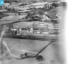 Later made the Elizabeth Shaw brand of chocolates. http://www.forlornbritain.co.uk/elizshaw.php |
BruceR |
Friday 21st of December 2012 10:17:36 PM |
Mangotsfield Station - Bristol ahead, Bath to the left, Gloucester to the right. |
Head-in-the-Clouds |
Monday 10th of December 2012 03:27:57 PM |


