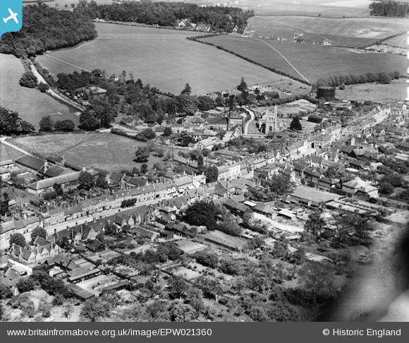
EPW021360 ENGLAND (1928). St Mary's Church and the High Street, Amersham, 1928
© Copyright OpenStreetMap contributors and licensed by the OpenStreetMap Foundation. 2024. Cartography is licensed as CC BY-SA.
Nearby Images (13)
Details
| Title | [EPW021360] St Mary's Church and the High Street, Amersham, 1928 |
| Reference | EPW021360 |
| Date | 27-May-1928 |
| Link | |
| Place name | AMERSHAM |
| Parish | AMERSHAM |
| District | |
| Country | ENGLAND |
| Easting / Northing | 495647, 197383 |
| Longitude / Latitude | -0.61684189753908, 51.666609083631 |
| National Grid Reference | SU956974 |
Pins
 HoaresatAmersham |
Tuesday 17th of June 2014 11:26:18 PM | |
 HoaresatAmersham |
Tuesday 17th of June 2014 10:54:42 PM |


![[EPW021360] St Mary's Church and the High Street, Amersham, 1928](http://britainfromabove.org.uk/sites/all/libraries/aerofilms-images/public/100x100/EPW/021/EPW021360.jpg)
![[EAW013619] The High Street, Whielden Street and environs, Amersham Old Town, 1948](http://britainfromabove.org.uk/sites/all/libraries/aerofilms-images/public/100x100/EAW/013/EAW013619.jpg)
![[EAW013620] The High Street and environs, Amersham Old Town, 1948. This image has been produced from a damaged negative.](http://britainfromabove.org.uk/sites/all/libraries/aerofilms-images/public/100x100/EAW/013/EAW013620.jpg)
![[EAW013622] The High Street and environs, Amersham Old Town, 1948. This image has been produced from a damaged negative.](http://britainfromabove.org.uk/sites/all/libraries/aerofilms-images/public/100x100/EAW/013/EAW013622.jpg)
![[EPW021362] St Mary's Church and the High Street, Amersham, 1928](http://britainfromabove.org.uk/sites/all/libraries/aerofilms-images/public/100x100/EPW/021/EPW021362.jpg)
![[EPW021361] St Mary's Church and the High Street, Amersham, 1928](http://britainfromabove.org.uk/sites/all/libraries/aerofilms-images/public/100x100/EPW/021/EPW021361.jpg)
![[EAW013623] The High Street and St Mary's Church, Amersham Old Town, 1948](http://britainfromabove.org.uk/sites/all/libraries/aerofilms-images/public/100x100/EAW/013/EAW013623.jpg)
![[EPW017830] St Mary's Church and the High Street, Amersham Old Town, 1927](http://britainfromabove.org.uk/sites/all/libraries/aerofilms-images/public/100x100/EPW/017/EPW017830.jpg)
![[EPW017835] St Mary's Church and Whieldon Street, Amersham Old Town, 1927](http://britainfromabove.org.uk/sites/all/libraries/aerofilms-images/public/100x100/EPW/017/EPW017835.jpg)
![[EPW021359] St Mary's Church and the High Street, Amersham, 1928](http://britainfromabove.org.uk/sites/all/libraries/aerofilms-images/public/100x100/EPW/021/EPW021359.jpg)
![[EPW017831] St Mary's Church and the High Street, Amersham Old Town, 1927](http://britainfromabove.org.uk/sites/all/libraries/aerofilms-images/public/100x100/EPW/017/EPW017831.jpg)
![[EAW013621] The High Street and environs, Amersham Old Town, 1948. This image has been produced from a print.](http://britainfromabove.org.uk/sites/all/libraries/aerofilms-images/public/100x100/EAW/013/EAW013621.jpg)
![[EAW013618] The High Street, Broadway and environs, Amersham Old Town, 1948. This image has been produced from a damaged negative.](http://britainfromabove.org.uk/sites/all/libraries/aerofilms-images/public/100x100/EAW/013/EAW013618.jpg)


