
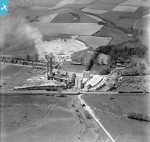
EPW020920 ENGLAND (1928). The Holborough Cement Works, Holborough, 1928

© Copyright OpenStreetMap contributors and licensed by the OpenStreetMap Foundation. 2024. Cartography is licensed as CC BY-SA.
Nearby Images (19)
EPW020920

EPW019911

EPW020921

EPW019912

EPW020923

EPW020918

EPW020925

EPW020919

EPW019902

EPW019906

EPW019904

EPW020924

EPW019908

EPW020922

EPW019901

EPW019903

EPW019909

EPW019907

EPW019910

Details
| Title | [EPW020920] The Holborough Cement Works, Holborough, 1928 |
| Reference | EPW020920 |
| Date | April-1928 |
| Link | |
| Place name | HOLBOROUGH |
| Parish | SNODLAND |
| District | |
| Country | ENGLAND |
| Easting / Northing | 570447, 162595 |
| Longitude / Latitude | 0.44720274073547, 51.336356291505 |
| National Grid Reference | TQ704626 |
Pins
 John Wass |
Friday 9th of December 2016 04:00:04 PM |
User Comment Contributions
For details, history and many links, see [[http://www.cementkilns.co.uk/cement_kiln_holborough.html]]. |
 Dylan Moore |
Thursday 18th of October 2012 09:12:06 PM |
 Holborough |
Dylan Moore |
Tuesday 16th of October 2012 08:06:44 PM |
Picture of Holborough Cement Plant shortly after its acquisition by the Red Triangle Group. The plant operated 1924-1984. The third kiln had been installed in 1926. |
Dylan Moore |
Tuesday 16th of October 2012 12:06:58 PM |


