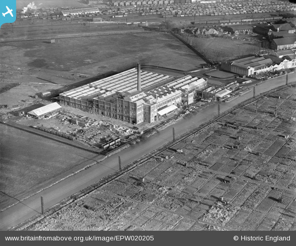
EPW020205 ENGLAND (1928). The Heinz Food Production Factory, Stonebridge, 1928
© Copyright OpenStreetMap contributors and licensed by the OpenStreetMap Foundation. 2024. Cartography is licensed as CC BY-SA.
Nearby Images (38)
Details
| Title | [EPW020205] The Heinz Food Production Factory, Stonebridge, 1928 |
| Reference | EPW020205 |
| Date | 5-January-1928 |
| Link | |
| Place name | STONEBRIDGE |
| Parish | |
| District | |
| Country | ENGLAND |
| Easting / Northing | 520054, 183330 |
| Longitude / Latitude | -0.26885792435109, 51.535612068027 |
| National Grid Reference | TQ201833 |
Pins
 classicforever |
Wednesday 27th of June 2012 03:38:08 PM | |
 classicforever |
Wednesday 27th of June 2012 03:36:12 PM |
User Comment Contributions
Most people would think of Heinz as being part of the Park Royal industrial estate. The regular strip running from side to side across the image is the Grand Union Canal Paddington Arm. Heinz had docking berths and two barges can be seen alongside towards the right of the image. |
 Harrow&Wembley |
Saturday 30th of June 2012 02:32:58 PM |
 classicforever |
Wednesday 27th of June 2012 03:33:48 PM |


![[EPW020205] The Heinz Food Production Factory, Stonebridge, 1928](http://britainfromabove.org.uk/sites/all/libraries/aerofilms-images/public/100x100/EPW/020/EPW020205.jpg)
![[EPW044842] The Heinz Food Factory, Grand Union Canal and environs, Harlesden, 1934](http://britainfromabove.org.uk/sites/all/libraries/aerofilms-images/public/100x100/EPW/044/EPW044842.jpg)
![[EPW025082] The Heinz Food Production Works, Stonebridge, 1928](http://britainfromabove.org.uk/sites/all/libraries/aerofilms-images/public/100x100/EPW/025/EPW025082.jpg)
![[EPW032155] The Heinz Food Production Works, Stonebridge, 1930](http://britainfromabove.org.uk/sites/all/libraries/aerofilms-images/public/100x100/EPW/032/EPW032155.jpg)
![[EPW025086] The Heinz Food Production Works, Stonebridge, 1928](http://britainfromabove.org.uk/sites/all/libraries/aerofilms-images/public/100x100/EPW/025/EPW025086.jpg)
![[EPW025081] The Heinz Food Production Works, Stonebridge, 1928](http://britainfromabove.org.uk/sites/all/libraries/aerofilms-images/public/100x100/EPW/025/EPW025081.jpg)
![[EPW025215] The H. J. Heinz and Co. factory, Harlesden, 1928](http://britainfromabove.org.uk/sites/all/libraries/aerofilms-images/public/100x100/EPW/025/EPW025215.jpg)
![[EPW025083] The Heinz Food Production Works, Stonebridge, 1928](http://britainfromabove.org.uk/sites/all/libraries/aerofilms-images/public/100x100/EPW/025/EPW025083.jpg)
![[EPW025221] The H. J. Heinz and Co. factory, Harlesden, 1928](http://britainfromabove.org.uk/sites/all/libraries/aerofilms-images/public/100x100/EPW/025/EPW025221.jpg)
![[EPW044848] The Heinz Food Factory and Grand Union Canal, Harlesden, 1934](http://britainfromabove.org.uk/sites/all/libraries/aerofilms-images/public/100x100/EPW/044/EPW044848.jpg)
![[EPW025087] The Heinz Food Production Works, Stonebridge, 1928](http://britainfromabove.org.uk/sites/all/libraries/aerofilms-images/public/100x100/EPW/025/EPW025087.jpg)
![[EPW025079] The Heinz Food Production Works, Stonebridge, 1928](http://britainfromabove.org.uk/sites/all/libraries/aerofilms-images/public/100x100/EPW/025/EPW025079.jpg)
![[EPW022718] The Heinz Food Production Factory, Lower Place, 1928](http://britainfromabove.org.uk/sites/all/libraries/aerofilms-images/public/100x100/EPW/022/EPW022718.jpg)
![[EPW025218] The H. J. Heinz and Co. factory, Harlesden, 1928](http://britainfromabove.org.uk/sites/all/libraries/aerofilms-images/public/100x100/EPW/025/EPW025218.jpg)
![[EPW025125] The Heinz Food Production Works, Stonebridge, 1928](http://britainfromabove.org.uk/sites/all/libraries/aerofilms-images/public/100x100/EPW/025/EPW025125.jpg)
![[EPW044841] The Heinz Food Factory, Grand Union Canal and environs, Harlesden, 1934](http://britainfromabove.org.uk/sites/all/libraries/aerofilms-images/public/100x100/EPW/044/EPW044841.jpg)
![[EPW044844] The Heinz Food Factory, Grand Union Canal and environs, Harlesden, 1934](http://britainfromabove.org.uk/sites/all/libraries/aerofilms-images/public/100x100/EPW/044/EPW044844.jpg)
![[EPW025124] The Heinz Food Production Works, Stonebridge, 1928](http://britainfromabove.org.uk/sites/all/libraries/aerofilms-images/public/100x100/EPW/025/EPW025124.jpg)
![[EPW025214] The H. J. Heinz and Co. factory, Harlesden, 1928](http://britainfromabove.org.uk/sites/all/libraries/aerofilms-images/public/100x100/EPW/025/EPW025214.jpg)
![[EPW025084] The Heinz Food Production Works, Stonebridge, 1928](http://britainfromabove.org.uk/sites/all/libraries/aerofilms-images/public/100x100/EPW/025/EPW025084.jpg)
![[EPW025078] The Heinz Food Production Works, Stonebridge, 1928](http://britainfromabove.org.uk/sites/all/libraries/aerofilms-images/public/100x100/EPW/025/EPW025078.jpg)
![[EPW025216] The H. J. Heinz and Co. factory, Harlesden, 1928](http://britainfromabove.org.uk/sites/all/libraries/aerofilms-images/public/100x100/EPW/025/EPW025216.jpg)
![[EPW044851] The Heinz Food Factory and Grand Union Canal, Harlesden, 1934](http://britainfromabove.org.uk/sites/all/libraries/aerofilms-images/public/100x100/EPW/044/EPW044851.jpg)
![[EPW025217] The H. J. Heinz and Co. factory, Harlesden, 1928](http://britainfromabove.org.uk/sites/all/libraries/aerofilms-images/public/100x100/EPW/025/EPW025217.jpg)
![[EPW025085] The Heinz Food Production Works, Stonebridge, 1928](http://britainfromabove.org.uk/sites/all/libraries/aerofilms-images/public/100x100/EPW/025/EPW025085.jpg)
![[EPW025122] The Heinz Food Production Works, Stonebridge, 1928](http://britainfromabove.org.uk/sites/all/libraries/aerofilms-images/public/100x100/EPW/025/EPW025122.jpg)
![[EPW025077] The Heinz Food Production Works, Stonebridge, 1928](http://britainfromabove.org.uk/sites/all/libraries/aerofilms-images/public/100x100/EPW/025/EPW025077.jpg)
![[EPW025123] The Heinz Food Production Works, Stonebridge, 1928](http://britainfromabove.org.uk/sites/all/libraries/aerofilms-images/public/100x100/EPW/025/EPW025123.jpg)
![[EPW025076] The Heinz Food Production Works, Stonebridge, 1928](http://britainfromabove.org.uk/sites/all/libraries/aerofilms-images/public/100x100/EPW/025/EPW025076.jpg)
![[EPW025219] The H. J. Heinz and Co. factory, Harlesden, 1928](http://britainfromabove.org.uk/sites/all/libraries/aerofilms-images/public/100x100/EPW/025/EPW025219.jpg)
![[EPW044846] The Heinz Food Factory, Grand Union Canal and environs, Harlesden, 1934](http://britainfromabove.org.uk/sites/all/libraries/aerofilms-images/public/100x100/EPW/044/EPW044846.jpg)
![[EPW044847] The Heinz Food Factory, Grand Union Canal and environs, Harlesden, 1934](http://britainfromabove.org.uk/sites/all/libraries/aerofilms-images/public/100x100/EPW/044/EPW044847.jpg)
![[EPW056368] The Heinz Food Production Factory, Stonebridge, 1938](http://britainfromabove.org.uk/sites/all/libraries/aerofilms-images/public/100x100/EPW/056/EPW056368.jpg)
![[EPW044840] The Heinz Food Factory, Grand Union Canal and environs, Harlesden, 1934](http://britainfromabove.org.uk/sites/all/libraries/aerofilms-images/public/100x100/EPW/044/EPW044840.jpg)
![[EPW044845] The Heinz Food Factory, Grand Union Canal and environs, Harlesden, 1934](http://britainfromabove.org.uk/sites/all/libraries/aerofilms-images/public/100x100/EPW/044/EPW044845.jpg)
![[EPW044843] The Heinz Food Factory and environs, Harlesden, 1934](http://britainfromabove.org.uk/sites/all/libraries/aerofilms-images/public/100x100/EPW/044/EPW044843.jpg)
![[EPW044849] The Heinz Food Factory, Grand Union Canal and environs, Harlesden, 1934](http://britainfromabove.org.uk/sites/all/libraries/aerofilms-images/public/100x100/EPW/044/EPW044849.jpg)
![[EPW044850] The Heinz Food Factory, Harlesden, 1934](http://britainfromabove.org.uk/sites/all/libraries/aerofilms-images/public/100x100/EPW/044/EPW044850.jpg)


