
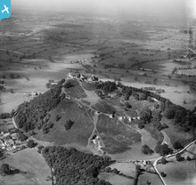
EPW019437 ENGLAND (1927). Beeston Castle, Beeston, from the south-east, 1927

© Copyright OpenStreetMap contributors and licensed by the OpenStreetMap Foundation. 2024. Cartography is licensed as CC BY-SA.
Nearby Images (10)
EPW019437

EAW000832

EPW040172

EAW013789

EPW019438

EPW019436

EPW040170

EAW013790

EAW013792

EAW013793

Details
| Title | [EPW019437] Beeston Castle, Beeston, from the south-east, 1927 |
| Reference | EPW019437 |
| Date | October-1927 |
| Link | |
| Place name | BEESTON |
| Parish | BEESTON |
| District | |
| Country | ENGLAND |
| Easting / Northing | 353868, 359028 |
| Longitude / Latitude | -2.6894867425687, 53.126127899785 |
| National Grid Reference | SJ539590 |
Pins
Be the first to add a comment to this image!
User Comment Contributions
 Beeston Castle |
 Robert - Cumbria |
Wednesday 27th of June 2012 06:59:51 PM |


