
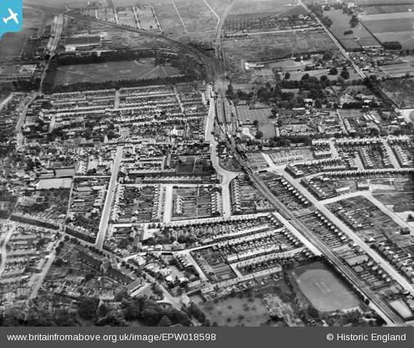
EPW018598 ENGLAND (1927). Station Road and environs, Faversham, 1927
© Copyright OpenStreetMap contributors and licensed by the OpenStreetMap Foundation. 2024. Cartography is licensed as CC BY-SA.
Nearby Images (6)
EPW018598

EPW018595

EAW028818

EAW028817

EPW018635

EPW018593

Details
| Title | [EPW018598] Station Road and environs, Faversham, 1927 |
| Reference | EPW018598 |
| Date | 22-June-1927 |
| Link | |
| Place name | FAVERSHAM |
| Parish | FAVERSHAM |
| District | |
| Country | ENGLAND |
| Easting / Northing | 601393, 161019 |
| Longitude / Latitude | 0.89006077511626, 51.312083442637 |
| National Grid Reference | TR014610 |
Pins
 Mike Floate |
Friday 4th of January 2013 08:27:01 PM | |
 Valentin |
Sunday 28th of October 2012 06:32:21 AM | |
John Russell |
Sunday 1st of July 2012 03:12:02 PM | |
John Russell |
Sunday 1st of July 2012 03:11:23 PM | |
John Russell |
Sunday 1st of July 2012 03:05:05 PM | |
John Russell |
Sunday 1st of July 2012 03:04:13 PM | |
John Russell |
Sunday 1st of July 2012 03:03:05 PM | |
John Russell |
Sunday 1st of July 2012 03:00:01 PM | |
John Russell |
Sunday 1st of July 2012 02:59:06 PM |
User Comment Contributions
 Faversham Station and Engine Shed (at the top of the image). |
John Russell |
Sunday 1st of July 2012 03:13:58 PM |


