
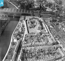
EPW018046 ENGLAND (1927). HM Prison, Shrewsbury, 1927

© Copyright OpenStreetMap contributors and licensed by the OpenStreetMap Foundation. 2024. Cartography is licensed as CC BY-SA.
Nearby Images (2)
EPW018046

EPW018050

Details
| Title | [EPW018046] HM Prison, Shrewsbury, 1927 |
| Reference | EPW018046 |
| Date | May-1927 |
| Link | |
| Place name | SHREWSBURY |
| Parish | SHREWSBURY |
| District | |
| Country | ENGLAND |
| Easting / Northing | 349629, 312994 |
| Longitude / Latitude | -2.7456935188203, 52.71191827669 |
| National Grid Reference | SJ496130 |
Pins
 kw66 |
Wednesday 8th of January 2020 10:48:45 PM | |
Barney Rubble |
Friday 31st of March 2017 08:57:42 AM | |
Andrew Bennett |
Monday 8th of July 2013 10:46:21 PM | |
MB |
Tuesday 11th of December 2012 10:37:16 AM | |
MB |
Saturday 6th of October 2012 11:14:20 AM | |
MB |
Saturday 6th of October 2012 11:12:48 AM | |
MB |
Saturday 6th of October 2012 11:12:19 AM | |
MB |
Saturday 6th of October 2012 11:10:55 AM | |
MB |
Saturday 6th of October 2012 11:10:19 AM | |
jackthebean |
Saturday 30th of June 2012 07:33:17 PM | |
jackthebean |
Saturday 30th of June 2012 07:30:14 PM |
User Comment Contributions
 Shrewsbury station and yard |
Martin |
Friday 6th of July 2012 07:09:58 PM |


