
EPW015104 ENGLAND (1926). The High Street and environs, Aldridge, from the west, 1926

© Copyright OpenStreetMap contributors and licensed by the OpenStreetMap Foundation. 2024. Cartography is licensed as CC BY-SA.
Nearby Images (2)
EPW015104

EPW015102

Details
| Title | [EPW015104] The High Street and environs, Aldridge, from the west, 1926 |
| Reference | EPW015104 |
| Date | 12-April-1926 |
| Link | |
| Place name | ALDRIDGE |
| Parish | |
| District | |
| Country | ENGLAND |
| Easting / Northing | 405843, 300802 |
| Longitude / Latitude | -1.9137122667467, 52.60461650047 |
| National Grid Reference | SK058008 |
Pins
 Jamie |
Saturday 21st of October 2023 05:30:36 PM | |
Jamie |
Saturday 21st of October 2023 05:30:02 PM | |
Jamie |
Saturday 21st of October 2023 05:29:30 PM | |
Jamie |
Saturday 21st of October 2023 05:28:45 PM | |
Jamie |
Saturday 21st of October 2023 05:28:01 PM | |
Jamie |
Saturday 21st of October 2023 05:27:30 PM | |
Jamie |
Saturday 21st of October 2023 05:26:35 PM | |
janine |
Monday 9th of June 2014 11:58:31 AM | |
 Barry Carpenter |
Monday 25th of June 2012 10:02:11 PM |
User Comment Contributions
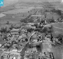 The old High Street, long since gone to the 1960's redevelopment. |
Barry Carpenter |
Tuesday 26th of June 2012 03:20:57 PM |


