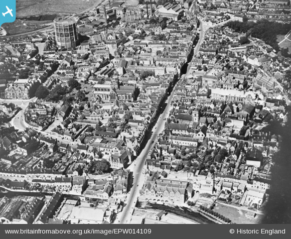
EPW014109 ENGLAND (1925). The town centre, Stafford, 1925. This image has been produced from a copy-negative.
© Copyright OpenStreetMap contributors and licensed by the OpenStreetMap Foundation. 2024. Cartography is licensed as CC BY-SA.
Nearby Images (17)
Details
| Title | [EPW014109] The town centre, Stafford, 1925. This image has been produced from a copy-negative. |
| Reference | EPW014109 |
| Date | August-1925 |
| Link | |
| Place name | STAFFORD |
| Parish | |
| District | |
| Country | ENGLAND |
| Easting / Northing | 392191, 323196 |
| Longitude / Latitude | -2.1158529633654, 52.805928333405 |
| National Grid Reference | SJ922232 |
Pins
Be the first to add a comment to this image!


![[EPW014109] The town centre, Stafford, 1925. This image has been produced from a copy-negative.](http://britainfromabove.org.uk/sites/all/libraries/aerofilms-images/public/100x100/EPW/014/EPW014109.jpg)
![[EAW024955] HM Prison Stafford, St Mary's Church and the town centre, Stafford, from the south-east, 1949](http://britainfromabove.org.uk/sites/all/libraries/aerofilms-images/public/100x100/EAW/024/EAW024955.jpg)
![[EAW001866] St Mary's Church and the town centre, Stafford, 1946](http://britainfromabove.org.uk/sites/all/libraries/aerofilms-images/public/100x100/EAW/001/EAW001866.jpg)
![[EAW024958] St Mary's Church and the town centre, Stafford, 1949](http://britainfromabove.org.uk/sites/all/libraries/aerofilms-images/public/100x100/EAW/024/EAW024958.jpg)
![[EPW053375] Greengate Street, St Mary's Church and the town centre, Stafford, 1937](http://britainfromabove.org.uk/sites/all/libraries/aerofilms-images/public/100x100/EPW/053/EPW053375.jpg)
![[EAW001865] St Mary's Church, Greengate Street and the town centre, Stafford, 1946](http://britainfromabove.org.uk/sites/all/libraries/aerofilms-images/public/100x100/EAW/001/EAW001865.jpg)
![[EPW014106] The town centre, Stafford, 1925. This image has been produced from a copy-negative.](http://britainfromabove.org.uk/sites/all/libraries/aerofilms-images/public/100x100/EPW/014/EPW014106.jpg)
![[EAW024954] HM Prison Stafford and the town centre, Stafford, from the south-east, 1949](http://britainfromabove.org.uk/sites/all/libraries/aerofilms-images/public/100x100/EAW/024/EAW024954.jpg)
![[EPW053381] St Mary's Church and the town centre, Stafford, 1937](http://britainfromabove.org.uk/sites/all/libraries/aerofilms-images/public/100x100/EPW/053/EPW053381.jpg)
![[EPW053380] The Shire Hall, Gaolgate Street and the town centre, Stafford, 1937](http://britainfromabove.org.uk/sites/all/libraries/aerofilms-images/public/100x100/EPW/053/EPW053380.jpg)
![[EPW014113] The town centre, Stafford, 1925. This image has been produced from a copy-negative.](http://britainfromabove.org.uk/sites/all/libraries/aerofilms-images/public/100x100/EPW/014/EPW014113.jpg)
![[EPW034022] Victoria Park and the town centre, Stafford, 1930](http://britainfromabove.org.uk/sites/all/libraries/aerofilms-images/public/100x100/EPW/034/EPW034022.jpg)
![[EAW046078] The town centre, Stafford, 1952](http://britainfromabove.org.uk/sites/all/libraries/aerofilms-images/public/100x100/EAW/046/EAW046078.jpg)
![[EAW001867] Gaolgate Street, Stafford, 1946](http://britainfromabove.org.uk/sites/all/libraries/aerofilms-images/public/100x100/EAW/001/EAW001867.jpg)
![[EAW024957] St Mary's Church and the town centre, Stafford, from the south-west, 1949](http://britainfromabove.org.uk/sites/all/libraries/aerofilms-images/public/100x100/EAW/024/EAW024957.jpg)
![[EPW020050] The Town Centre, Stafford, 1927](http://britainfromabove.org.uk/sites/all/libraries/aerofilms-images/public/100x100/EPW/020/EPW020050.jpg)
![[EPW017027] The Stafford Corporation Gas Works, Stafford, 1926](http://britainfromabove.org.uk/sites/all/libraries/aerofilms-images/public/100x100/EPW/017/EPW017027.jpg)


