
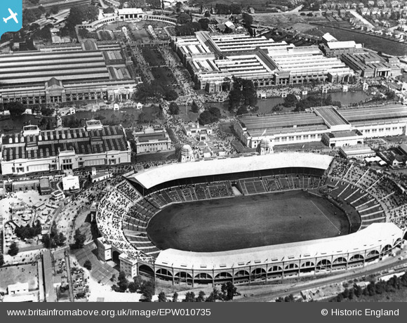
EPW010735 ENGLAND (1924). The British Empire Exhibition, Wembley Park, 1924
© Copyright OpenStreetMap contributors and licensed by the OpenStreetMap Foundation. 2024. Cartography is licensed as CC BY-SA.
Nearby Images (48)
EPW008076
 under construction, Wembley Park, from the north-west, 1922. This image has been produced from a copy-negative.")
EAW048879

EPW012752

EPW017623

EPW017635

EAW038566
 at Wembley Stadium, 1951. This image has been produced from a print.")
EPW009602

EPW046905

EAW048878

EPW046907

EAW017618

EAW017619

EAW018313

EPW017636

EPW026431

EPW020862

EPW026433

EPW009655

EPW010456

EPW026438

EPW010462

EPW045706

EPW034581

EAW018311

EPW046239

EPW046913

EPW010461

EPW010459

EAW014141
 Stadium, Wembley Park, 1948. This image has been produced from a damaged negative.")
EPW017625

EAW018312

EPW046910

EPW010458

EPW017624

EPW010457

EPW010460

EAW038567
 at Wembley Stadium, 1951. This image has been produced from a print.")
EPW045943

EPW046914

EPW046906

EPW045944

EPW035048

EAW018318

EAW018317

EPW045703

EAW018319

EPW009652

EPW009547

Details
| Title | [EPW010735] The British Empire Exhibition, Wembley Park, 1924 |
| Reference | EPW010735 |
| Date | June-1924 |
| Link | |
| Place name | WEMBLEY PARK |
| Parish | |
| District | |
| Country | ENGLAND |
| Easting / Northing | 519354, 185647 |
| Longitude / Latitude | -0.27816066383169, 51.55658659091 |
| National Grid Reference | TQ194856 |
Pins
Be the first to add a comment to this image!
User Comment Contributions
Image reversed left-right? Canada and CNR pavilions should be to East of Princes Path - the central avenue just North of the Stadium |
 CH |
Tuesday 3rd of June 2014 08:25:20 PM |


