
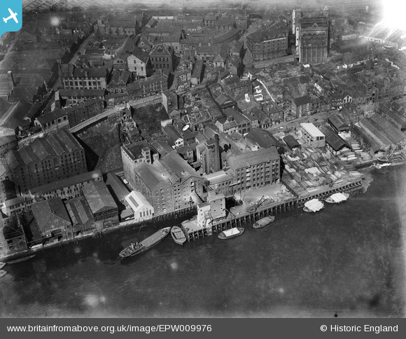
EPW009976 ENGLAND (1924). The Spillers and Bakers Mill and Wharf, Newcastle upon Tyne, 1924
© Copyright OpenStreetMap contributors and licensed by the OpenStreetMap Foundation. 2024. Cartography is licensed as CC BY-SA.
Nearby Images (18)
EPW009976

EPW009975

EPW009978

EPW009979

EPW009977

EPW010343
 and environs, Newcastle upon Tyne, 1924. This image has been produced from a print.")
EPW060867

EPW010395
 and the surrounding city, Newcastle upon Tyne, 1924. This image has been produced from a print.")
EPW009980
, Newcastle upon Tyne, 1924")
EPW010392

EPW010345
, Newcastle upon Tyne, 1924")
EPW010344
, Newcastle upon Tyne, 1924")
EPW010342

EPW010411

EPW010341
 and environs, Newcastle upon Tyne, 1924")
EAW405203

EPW010393

EPW048800

Details
| Title | [EPW009976] The Spillers and Bakers Mill and Wharf, Newcastle upon Tyne, 1924 |
| Reference | EPW009976 |
| Date | 10-April-1924 |
| Link | |
| Place name | NEWCASTLE UPON TYNE |
| Parish | |
| District | |
| Country | ENGLAND |
| Easting / Northing | 424918, 563621 |
| Longitude / Latitude | -1.6107501379403, 54.966514235133 |
| National Grid Reference | NZ249636 |


