
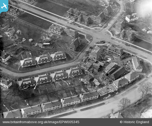
EPW005345 ENGLAND (1921). Lascelles Avenue and environs under construction, West Harrow, 1921
© Copyright OpenStreetMap contributors and licensed by the OpenStreetMap Foundation. 2024. Cartography is licensed as CC BY-SA.
Nearby Images (5)
EPW005345

EPW000465

EAW028794

EPW005448A

EPW000470

Details
| Title | [EPW005345] Lascelles Avenue and environs under construction, West Harrow, 1921 |
| Reference | EPW005345 |
| Date | January-1921 |
| Link | |
| Place name | WEST HARROW |
| Parish | |
| District | |
| Country | ENGLAND |
| Easting / Northing | 514849, 187713 |
| Longitude / Latitude | -0.34244610614885, 51.57609251706 |
| National Grid Reference | TQ148877 |
Pins
 The Laird |
Thursday 20th of February 2020 01:41:02 AM | |
JamesMac |
Friday 23rd of August 2013 01:58:34 AM | |
JamesMac |
Friday 23rd of August 2013 01:57:42 AM | |
JamesMac |
Friday 23rd of August 2013 01:57:05 AM | |
JamesMac |
Friday 23rd of August 2013 01:56:30 AM |
User Comment Contributions
It seems certain it's a Monday ... by the washing! |
 Maurice |
Monday 28th of October 2013 06:20:10 AM |
Dear all, Thanks for looking at this one - although the Rooks Hill/Parkway junction is tempting, this doesn't seem to be Welwyn Garden City. The original Aerofilms Ltd Register entry is blank, with shots before and after labelled Harrow. Do you have any other ideas where this might be? Katy Whitaker Britain from Above Cataloguer. |
Katy Whitaker |
Tuesday 23rd of October 2012 12:27:47 PM |
Ok it is the junction of Ford Close and Charles Cresent with Lascelles Ave. The Dorma-bungalows are still there on the 1945 Google earth view but are now flats |
Dave Brunt |
Tuesday 3rd of July 2012 05:52:12 PM |
Dave Brunt, thank you! Lascelles Avenue it is, under construction. We'll update the catalogue and the revised record with the correct location will appear here in due course. Yours, Katy Britain from Above Cataloguing Team Leader |
Katy Whitaker |
Tuesday 23rd of October 2012 12:27:47 PM |
BigglesH may very well be correct that this is Welwyn, but the coordinates given don't match the picture. That location can be seen here: http://wtp2.appspot.com/wheresthepath.htm?lat=51.79388335661288&lon=-0.18318564508619295&gz=18&oz=8>=1 All the houses in the photo have hipped roofs whereas none of them do in the present-day aerial view. Also, there is a crossroads in the photo which is not present at the suggested location. There are houses with hipped roofs elsewhere in welwyn (e.g. in the Peartree district) but I've not been able to find a good match with the photo. |
PeterFacey |
Thursday 28th of June 2012 09:56:06 PM |
I did not claim it to be Welwyn, nor did I set the location Lat/Long. |
BigglesH |
Thursday 28th of June 2012 09:56:06 PM |
It seems unlikely that this is Welwyn Garden City as very little existed in 1921 and nothing matched this road arrangement then. |
John |
Thursday 28th of June 2012 09:20:03 PM |
Estate being built - some occupants (see washing drying) but back gardens are a mess. |
BigglesH |
Tuesday 26th of June 2012 03:27:06 AM |


