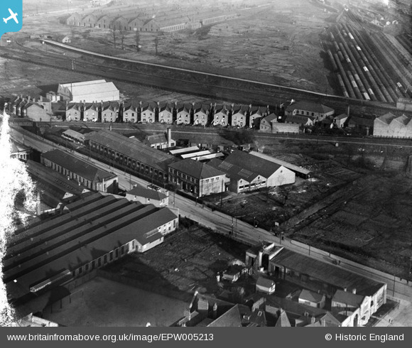
EPW005213 ENGLAND (1921). George Philip and Sons Geographical Institute, Acton, 1921
© Copyright OpenStreetMap contributors and licensed by the OpenStreetMap Foundation. 2024. Cartography is licensed as CC BY-SA.
Nearby Images (32)
Details
| Title | [EPW005213] George Philip and Sons Geographical Institute, Acton, 1921 |
| Reference | EPW005213 |
| Date | 21-January-1921 |
| Link | |
| Place name | ACTON |
| Parish | |
| District | |
| Country | ENGLAND |
| Easting / Northing | 521165, 182193 |
| Longitude / Latitude | -0.25323688520021, 51.525154987936 |
| National Grid Reference | TQ212822 |


![[EPW005213] George Philip and Sons Geographical Institute, Acton, 1921](http://britainfromabove.org.uk/sites/all/libraries/aerofilms-images/public/100x100/EPW/005/EPW005213.jpg)
![[EPW005174] The Geographical Institute, North Acton, 1921](http://britainfromabove.org.uk/sites/all/libraries/aerofilms-images/public/100x100/EPW/005/EPW005174.jpg)
![[EPW005210] George Philip and Sons Geographical Institute, Acton, 1921](http://britainfromabove.org.uk/sites/all/libraries/aerofilms-images/public/100x100/EPW/005/EPW005210.jpg)
![[EPW005171] The Geographical Institute, North Acton, 1921](http://britainfromabove.org.uk/sites/all/libraries/aerofilms-images/public/100x100/EPW/005/EPW005171.jpg)
![[EPW005173] The Geographical Institute, North Acton, 1921](http://britainfromabove.org.uk/sites/all/libraries/aerofilms-images/public/100x100/EPW/005/EPW005173.jpg)
![[EPW005212] George Philip and Sons Geographical Institute, Acton, 1921](http://britainfromabove.org.uk/sites/all/libraries/aerofilms-images/public/100x100/EPW/005/EPW005212.jpg)
![[EPW005172] The Geographical Institute, North Acton, 1921](http://britainfromabove.org.uk/sites/all/libraries/aerofilms-images/public/100x100/EPW/005/EPW005172.jpg)
![[EPW005211] George Philip and Sons Geographical Institute, Acton, 1921](http://britainfromabove.org.uk/sites/all/libraries/aerofilms-images/public/100x100/EPW/005/EPW005211.jpg)
![[EPW044097] The George Philip and Son Geographical Institute, North Acton, 1934](http://britainfromabove.org.uk/sites/all/libraries/aerofilms-images/public/100x100/EPW/044/EPW044097.jpg)
![[EPW044098] The George Philip and Son Geographical Institute, North Acton, 1934](http://britainfromabove.org.uk/sites/all/libraries/aerofilms-images/public/100x100/EPW/044/EPW044098.jpg)
![[EPW005183] George Philip and Sons Geographical Institute, Acton, 1921](http://britainfromabove.org.uk/sites/all/libraries/aerofilms-images/public/100x100/EPW/005/EPW005183.jpg)
![[EPW005185] George Philip and Sons Geographical Institute, Acton, 1921](http://britainfromabove.org.uk/sites/all/libraries/aerofilms-images/public/100x100/EPW/005/EPW005185.jpg)
![[EPW005214] George Philip and Sons Geographical Institute, Acton, 1921](http://britainfromabove.org.uk/sites/all/libraries/aerofilms-images/public/100x100/EPW/005/EPW005214.jpg)
![[EPW044100] The George Philip and Son Geographical Institute, North Acton, 1934](http://britainfromabove.org.uk/sites/all/libraries/aerofilms-images/public/100x100/EPW/044/EPW044100.jpg)
![[EPW058336] The Old Oak Common Railway Sidings and the surrounding industrial area, North Acton, 1938](http://britainfromabove.org.uk/sites/all/libraries/aerofilms-images/public/100x100/EPW/058/EPW058336.jpg)
![[EPW044099] The George Philip and Son Geographical Institute, North Acton, 1934](http://britainfromabove.org.uk/sites/all/libraries/aerofilms-images/public/100x100/EPW/044/EPW044099.jpg)
![[EPW005170] The Rotax Works, other factories and the Geographical Institute, North Acton, 1921](http://britainfromabove.org.uk/sites/all/libraries/aerofilms-images/public/100x100/EPW/005/EPW005170.jpg)
![[EPW005169] Factories and the Geographical Institute, North Acton, from the south, 1921](http://britainfromabove.org.uk/sites/all/libraries/aerofilms-images/public/100x100/EPW/005/EPW005169.jpg)
![[EAW033527] Rotax Ltd and other industries at Willesden Junction, North Acton, 1950. This image was marked by Aerofilms Ltd for photo editing.](http://britainfromabove.org.uk/sites/all/libraries/aerofilms-images/public/100x100/EAW/033/EAW033527.jpg)
![[EAW009102] The Mond Nickel Co Refinery on Bashley Road and environs, North Acton, from the south-east, 1947](http://britainfromabove.org.uk/sites/all/libraries/aerofilms-images/public/100x100/EAW/009/EAW009102.jpg)
![[EPW034968] Rotax Ltd and other industries at Willesden Junction, North Acton, 1931](http://britainfromabove.org.uk/sites/all/libraries/aerofilms-images/public/100x100/EPW/034/EPW034968.jpg)
![[EPW034965] Rotax Ltd and other industries at Willesden Junction, North Acton, 1931](http://britainfromabove.org.uk/sites/all/libraries/aerofilms-images/public/100x100/EPW/034/EPW034965.jpg)
![[EPW034966] Rotax Ltd and other industries at Willesden Junction, North Acton, 1931](http://britainfromabove.org.uk/sites/all/libraries/aerofilms-images/public/100x100/EPW/034/EPW034966.jpg)
![[EPW034964] Rotax Ltd and other industries at Willesden Junction, North Acton, 1931](http://britainfromabove.org.uk/sites/all/libraries/aerofilms-images/public/100x100/EPW/034/EPW034964.jpg)
![[EPW034967] Rotax Ltd and other industries at Willesden Junction, North Acton, 1931](http://britainfromabove.org.uk/sites/all/libraries/aerofilms-images/public/100x100/EPW/034/EPW034967.jpg)
![[EPW046954] The Mond Nickel Co Refinery, North Acton, 1935](http://britainfromabove.org.uk/sites/all/libraries/aerofilms-images/public/100x100/EPW/046/EPW046954.jpg)
![[EPW046956] The Mond Nickel Co Refinery, North Acton, 1935](http://britainfromabove.org.uk/sites/all/libraries/aerofilms-images/public/100x100/EPW/046/EPW046956.jpg)
![[EAW009104] The Mond Nickel Co Refinery on Bashley Road and environs, North Acton, 1947](http://britainfromabove.org.uk/sites/all/libraries/aerofilms-images/public/100x100/EAW/009/EAW009104.jpg)


