
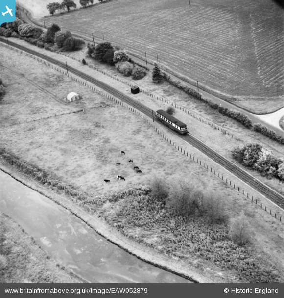
EAW052879 ENGLAND (1953). A GWR railcar (No. 27) on the Lambourne Valley Railway, near Boxford, 1953
© Copyright OpenStreetMap contributors and licensed by the OpenStreetMap Foundation. 2024. Cartography is licensed as CC BY-SA.
Nearby Images (2)
EAW052879
 on the Lambourne Valley Railway, near Boxford, 1953")
EAW052880
 on the Lambourne Valley Railway, near Boxford, 1953")
Details
| Title | [EAW052879] A GWR railcar (No. 27) on the Lambourne Valley Railway, near Boxford, 1953 |
| Reference | EAW052879 |
| Date | 16-October-1953 |
| Link | |
| Place name | BOXFORD |
| Parish | BOXFORD |
| District | |
| Country | ENGLAND |
| Easting / Northing | 442977, 170510 |
| Longitude / Latitude | -1.3817132811079, 51.431469335026 |
| National Grid Reference | SU430705 |
Pins
 Robert Smith |
Tuesday 23rd of December 2014 06:59:23 PM | |
Painted in the livery known as carmine and cream - red & white, affectionately called "blood and custard". This train [railcar] is heading towards Newbury. |
Nowy Paul |
Saturday 2nd of April 2016 11:27:28 AM |
 Class31 |
Tuesday 4th of November 2014 08:11:02 PM | |
Class31 |
Tuesday 4th of November 2014 08:06:26 PM | |
Class31 |
Tuesday 4th of November 2014 07:59:12 PM | |
Class31 |
Tuesday 4th of November 2014 07:58:37 PM |
User Comment Contributions
Location is near Boxford in the Lambourn Valley. |
Class31 |
Wednesday 5th of November 2014 08:51:44 AM |
excellent work. I have been searching Herefordshire! This Lambourn line wasn't on my 1961 BR map. |
TomRobin |
Tuesday 4th of November 2014 10:44:53 PM |
Thank you for your kind comments TomRobin as always. I'd been keeping an eye on this pair of images but I had largely discounted them as being too hard because of the lack of reference points. After seeing your posts about Yeovil last night I had another think when the Lambourn branch line came to mind. A lightly used line which might have been suited to diesel railcars. It also ran alongside a river and a valley road. I followed the line using the 6 inch Ordnance Survey maps from the National Library of Scotland and there it was. The difficulty here was to narrow down the locations. As you can see I was lucky I actually only looked at the Staines West and Lambourn branch railways. What fantastic images of a "moment in time" when the GWR and British Railways were attempting to come to terms with the loss of traffic to the roads. The railway here is long gone. Happy hunting with more unidentified photos. |
Class31 |
Wednesday 5th of November 2014 08:51:44 AM |
We are looking south. |
Class31 |
Tuesday 4th of November 2014 08:11:56 PM |
I believe that I have a result here on the Lambourn Branch for both pictures near to Coombesbury Farm. |
Class31 |
Tuesday 4th of November 2014 07:56:56 PM |
Eureka |
Class31 |
Tuesday 4th of November 2014 07:54:30 PM |
EAW052881 is of King Alfred's Tower, South Brewham, 1953 |
Class31 |
Tuesday 4th of November 2014 07:17:09 PM |
I have looked at most of the lines around Yeovil and Wells not found anything yet |
TomRobin |
Tuesday 4th of November 2014 07:17:09 PM |
I think that I'll have a look at the Staines West branch. |
Class31 |
Friday 31st of October 2014 05:51:10 PM |
I don't think it is the Staines branch. |
Class31 |
Friday 31st of October 2014 05:51:10 PM |
Not on the Yeovil to Langport line |
TomRobin |
Friday 31st of October 2014 04:33:09 PM |
Is it a river or wide canal? |
TomRobin |
Friday 31st of October 2014 04:21:12 PM |
see also EAW052880 same spot |
TomRobin |
Friday 31st of October 2014 04:20:01 PM |


