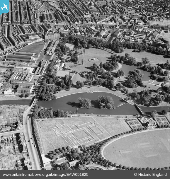
EAW051825 ENGLAND (1953). Abbey Park and the site of Leicester Abbey, Leicester, 1953
© Copyright OpenStreetMap contributors and licensed by the OpenStreetMap Foundation. 2024. Cartography is licensed as CC BY-SA.
Nearby Images (16)
Details
| Title | [EAW051825] Abbey Park and the site of Leicester Abbey, Leicester, 1953 |
| Reference | EAW051825 |
| Date | 1-September-1953 |
| Link | |
| Place name | LEICESTER |
| Parish | |
| District | |
| Country | ENGLAND |
| Easting / Northing | 458683, 305867 |
| Longitude / Latitude | -1.1325399969241, 52.647011279312 |
| National Grid Reference | SK587059 |
Pins
Be the first to add a comment to this image!


![[EAW051825] Abbey Park and the site of Leicester Abbey, Leicester, 1953](http://britainfromabove.org.uk/sites/all/libraries/aerofilms-images/public/100x100/EAW/051/EAW051825.jpg)
![[EAW043361] Abbey Park and the Abbey Grounds, Leicester, 1952](http://britainfromabove.org.uk/sites/all/libraries/aerofilms-images/public/100x100/EAW/043/EAW043361.jpg)
![[EAW043360] Abbey Park, Leicester, 1952](http://britainfromabove.org.uk/sites/all/libraries/aerofilms-images/public/100x100/EAW/043/EAW043360.jpg)
![[EAW051827] Abbey Park and The Oval, Leicester, 1953](http://britainfromabove.org.uk/sites/all/libraries/aerofilms-images/public/100x100/EAW/051/EAW051827.jpg)
![[EAW010416] T.G. Hirst & Co Ltd Fancy Hosiery Factory on Abbey Park Road, Abbey Park, 1947. This image was marked by Aerofilms Ltd for photo editing.](http://britainfromabove.org.uk/sites/all/libraries/aerofilms-images/public/100x100/EAW/010/EAW010416.jpg)
![[EAW010418] T.G. Hirst & Co Ltd Fancy Hosiery Factory, Abbey Park, 1947. This image was marked by Aerofilms Ltd for photo editing.](http://britainfromabove.org.uk/sites/all/libraries/aerofilms-images/public/100x100/EAW/010/EAW010418.jpg)
![[EPW055004] Abbey Park, Leicester, 1937](http://britainfromabove.org.uk/sites/all/libraries/aerofilms-images/public/100x100/EPW/055/EPW055004.jpg)
![[EAW024251] The Abbey Grounds (The Oval) and the site of Leicester Abbey, Leicester, 1949](http://britainfromabove.org.uk/sites/all/libraries/aerofilms-images/public/100x100/EAW/024/EAW024251.jpg)
![[EPW055013] Leicester Abbey, Leicester, 1937](http://britainfromabove.org.uk/sites/all/libraries/aerofilms-images/public/100x100/EPW/055/EPW055013.jpg)
![[EAW010423] T.G. Hirst & Co Ltd Fancy Hosiery Factory, Abbey Park, 1947. This image was marked by Aerofilms Ltd for photo editing.](http://britainfromabove.org.uk/sites/all/libraries/aerofilms-images/public/100x100/EAW/010/EAW010423.jpg)
![[EPW047640] Abbey Park and environs, Leicester, from the north-east, 1935](http://britainfromabove.org.uk/sites/all/libraries/aerofilms-images/public/100x100/EPW/047/EPW047640.jpg)
![[EAW010420] T.G. Hirst & Co Ltd Fancy Hosiery Factory, Abbey Park, 1947. This image was marked by Aerofilms Ltd for photo editing.](http://britainfromabove.org.uk/sites/all/libraries/aerofilms-images/public/100x100/EAW/010/EAW010420.jpg)
![[EAW024248] Abbey Park, Leicester, 1949](http://britainfromabove.org.uk/sites/all/libraries/aerofilms-images/public/100x100/EAW/024/EAW024248.jpg)
![[EAW024250] The Abbey Grounds (The Oval) and the site of Leicester Abbey, Leicester, 1949](http://britainfromabove.org.uk/sites/all/libraries/aerofilms-images/public/100x100/EAW/024/EAW024250.jpg)
![[EAW010417] T.G. Hirst & Co Ltd Fancy Hosiery Factory and environs, Abbey Park, 1947. This image was marked by Aerofilms Ltd for photo editing.](http://britainfromabove.org.uk/sites/all/libraries/aerofilms-images/public/100x100/EAW/010/EAW010417.jpg)
![[EAW010419] T.G. Hirst & Co Ltd Fancy Hosiery Factory and environs, Abbey Park, 1947. This image was marked by Aerofilms Ltd for photo editing.](http://britainfromabove.org.uk/sites/all/libraries/aerofilms-images/public/100x100/EAW/010/EAW010419.jpg)


