
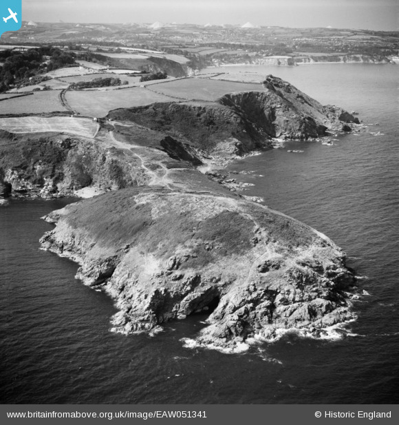
EAW051341 ENGLAND (1953). Black Head, The Bite and the surrounding area, Hallane, from the south-east, 1953
© Copyright OpenStreetMap contributors and licensed by the OpenStreetMap Foundation. 2024. Cartography is licensed as CC BY-SA.
Nearby Images (3)
EAW051341

EAW051340

EAW004893

Details
| Title | [EAW051341] Black Head, The Bite and the surrounding area, Hallane, from the south-east, 1953 |
| Reference | EAW051341 |
| Date | 11-August-1953 |
| Link | |
| Place name | HALLANE |
| Parish | ST. AUSTELL BAY |
| District | |
| Country | ENGLAND |
| Easting / Northing | 203983, 47888 |
| Longitude / Latitude | -4.7525950767492, 50.297709344242 |
| National Grid Reference | SX040479 |
Pins
 CornwallPhil |
Thursday 27th of November 2014 10:04:45 PM | |
CornwallPhil |
Thursday 27th of November 2014 10:03:28 PM | |
CornwallPhil |
Thursday 27th of November 2014 10:02:40 PM | |
CornwallPhil |
Thursday 27th of November 2014 10:01:54 PM | |
CornwallPhil |
Thursday 27th of November 2014 10:01:10 PM | |
CornwallPhil |
Thursday 27th of November 2014 10:00:38 PM |
User Comment Contributions
 Rifle Range on Black Head used by British Army, the Home Guard and US Army, plus St Austell Bay Bombing Range Quadrant Shelters (both are visible in this photo). |
CornwallPhil |
Thursday 27th of November 2014 10:06:44 PM |


