
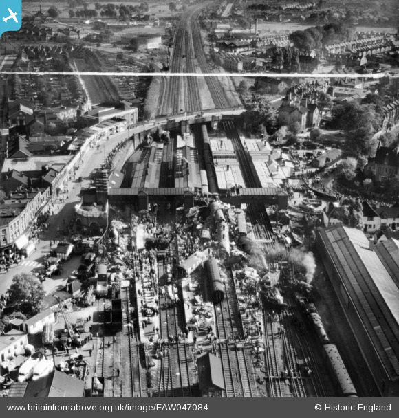
EAW047084 ENGLAND (1952). The aftermath of the Harrow and Wealdstone rail crash, Wealdstone, 1952. This image was marked by Aerofilms Ltd for photo editing.
© Copyright OpenStreetMap contributors and licensed by the OpenStreetMap Foundation. 2024. Cartography is licensed as CC BY-SA.
Nearby Images (24)
EAW047084

EAW047072

EAW047080

EAW047082

EAW047085

EPW053686

EAW047076

EAW047079

EAW047075

EAW047078

EAW047077

EAW047073

EAW047081

EAW047069

EAW047067

EAW047083

EPW005359

EAW047065

EAW047071

EAW047074

EAW047068

EAW047070

EAW047066

EPW025548

Details
| Title | [EAW047084] The aftermath of the Harrow and Wealdstone rail crash, Wealdstone, 1952. This image was marked by Aerofilms Ltd for photo editing. |
| Reference | EAW047084 |
| Date | 8-October-1952 |
| Link | |
| Place name | WEALDSTONE |
| Parish | |
| District | |
| Country | ENGLAND |
| Easting / Northing | 515457, 189463 |
| Longitude / Latitude | -0.33309952948914, 51.591698289408 |
| National Grid Reference | TQ155895 |
Pins
 Sweet Pete |
Sunday 1st of February 2015 02:19:20 PM |
User Comment Contributions
Please don't crop this. It shows the Railway Hotel and how it fitted in with the local area. The Railway Hotel is famous in its own right. The area has completely changed (Moon House/Daltry House), Harrow Central Mosque, Civic Centre - this is a valuable record. |
JGT |
Monday 23rd of June 2014 03:19:20 PM |


