
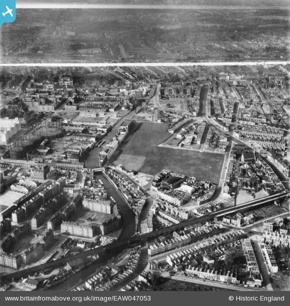
EAW047053 ENGLAND (1952). King George's Field and the surrounding area, Mile End, 1952. This image was marked by Aerofilms Ltd for photo editing.
© Copyright OpenStreetMap contributors and licensed by the OpenStreetMap Foundation. 2024. Cartography is licensed as CC BY-SA.
Nearby Images (5)
EAW047053

EAW047050

EAW047052

EAW047054

EAW047055

Details
| Title | [EAW047053] King George's Field and the surrounding area, Mile End, 1952. This image was marked by Aerofilms Ltd for photo editing. |
| Reference | EAW047053 |
| Date | 6-October-1952 |
| Link | |
| Place name | MILE END |
| Parish | |
| District | |
| Country | ENGLAND |
| Easting / Northing | 536435, 181928 |
| Longitude / Latitude | -0.033332808878911, 51.519290310485 |
| National Grid Reference | TQ364819 |
Pins
 Leslie B |
Monday 15th of August 2022 11:39:04 PM | |
Leslie B |
Monday 15th of August 2022 11:37:48 PM | |
ray Glenister |
Monday 4th of February 2019 07:39:17 AM | |
ray Glenister |
Monday 4th of February 2019 07:37:20 AM | |
ray Glenister |
Thursday 27th of July 2017 01:52:41 PM | |
ray Glenister |
Thursday 27th of July 2017 01:45:13 PM | |
 |
ray Glenister |
Thursday 27th of July 2017 01:30:50 PM |
Martin J. |
Wednesday 4th of November 2015 02:15:25 PM | |
hammer |
Saturday 8th of November 2014 05:05:22 PM | |
Ian |
Saturday 14th of June 2014 10:20:14 AM | |
Ian |
Saturday 14th of June 2014 10:18:49 AM | |
 |
Ian |
Saturday 14th of June 2014 10:11:19 AM |
Ian |
Saturday 14th of June 2014 09:48:08 AM | |
Ian |
Saturday 14th of June 2014 09:46:55 AM | |
Ian |
Saturday 14th of June 2014 09:40:17 AM | |
Ian |
Saturday 14th of June 2014 09:38:36 AM |


