
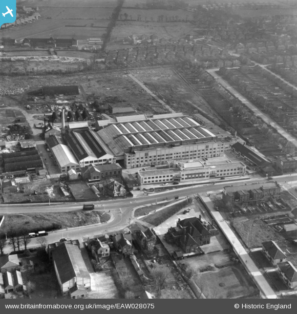
EAW028075 ENGLAND (1950). The Associated British Picture Corporation Film Studios off Shenley Road, Borehamwood, 1950. This image has been produced from a print.
© Copyright OpenStreetMap contributors and licensed by the OpenStreetMap Foundation. 2024. Cartography is licensed as CC BY-SA.
Nearby Images (40)
EAW028075

EPW021912

EAW028289
 Studios on Shenley Road, Borehamwood, 1950")
EAW028072

EAW028293
 Studios on Shenley Road, Borehamwood, 1950")
EAW028073

EAW028071

EAW028294
 Studios on Shenley Road, Borehamwood, 1950")
EAW028292
 Studios on Shenley Road, Borehamwood, 1950")
EAW028291
 Studios on Shenley Road, Borehamwood, 1950")
EPW046576

EPW025493

EPW021914

EAW028070

EPW021913

EAW028290
 Studios on Shenley Road, Borehamwood, 1950")
EPW025490

EPW025492

EPW061089
 Film Studios, Borehamwood, 1939")
EAW023317

EPW041245

EAW027912

EPW041244

EAW027906

EPW041243

EAW023318

EPW041248

EPW041247

EAW027907

EPW041242

EAW027910

EAW027903

EAW027904

EAW027909

EPW041246

EAW027908

EAW027914

EAW027913

EAW027905

EAW027911

Details
| Title | [EAW028075] The Associated British Picture Corporation Film Studios off Shenley Road, Borehamwood, 1950. This image has been produced from a print. |
| Reference | EAW028075 |
| Date | 1-March-1950 |
| Link | |
| Place name | BOREHAMWOOD |
| Parish | ELSTREE AND BOREHAMWOOD |
| District | |
| Country | ENGLAND |
| Easting / Northing | 519724, 196840 |
| Longitude / Latitude | -0.26900273037218, 51.657113588962 |
| National Grid Reference | TQ197968 |
Pins
Be the first to add a comment to this image!


