
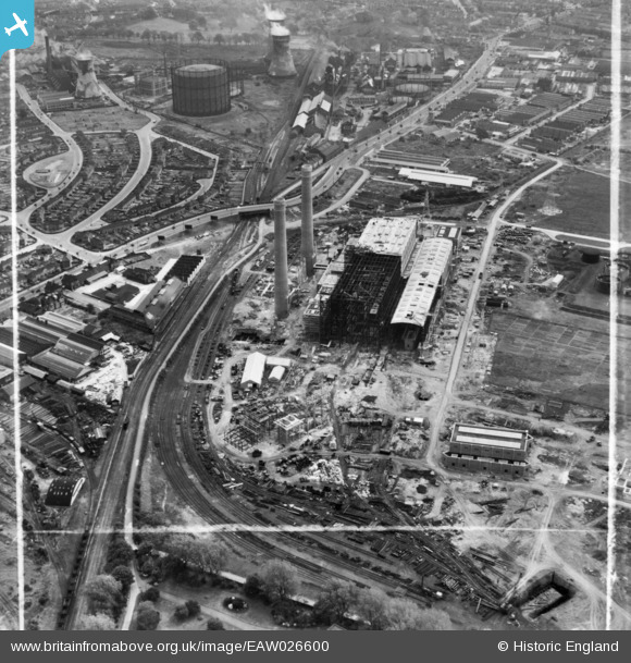
EAW026600 ENGLAND (1949). Croydon B Power Station under construction, Croydon, 1949. This image has been produced from a print marked by Aerofilms Ltd for photo editing.
© Copyright OpenStreetMap contributors and licensed by the OpenStreetMap Foundation. 2024. Cartography is licensed as CC BY-SA.
Nearby Images (20)
EAW026600

EAW026596

EAW013174

EAW013172

EAW026597

EAW013173

EAW013176

EAW013171

EAW013178

EAW013177

EAW026598

EAW026588

EAW026590

EAW013175

EAW013182

EAW013183

EAW013180

EAW026589

EAW026595

EAW026591

Details
| Title | [EAW026600] Croydon B Power Station under construction, Croydon, 1949. This image has been produced from a print marked by Aerofilms Ltd for photo editing. |
| Reference | EAW026600 |
| Date | 16-September-1949 |
| Link | |
| Place name | CROYDON |
| Parish | |
| District | |
| Country | ENGLAND |
| Easting / Northing | 530653, 166358 |
| Longitude / Latitude | -0.12237996932176, 51.380718543662 |
| National Grid Reference | TQ307664 |
Pins
Be the first to add a comment to this image!
User Comment Contributions
The towers are still there as part of the Ikea site. All the railway lines appear now to have shifted to roads; although return of the trains with a tramway running on some of the straight through routes. |
 RichardL |
Monday 21st of December 2015 09:12:31 AM |


