
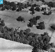
EAW025836 ENGLAND (1949). Waverley Abbey, Farnham, 1949. This image has been produced from a print.

© Copyright OpenStreetMap contributors and licensed by the OpenStreetMap Foundation. 2024. Cartography is licensed as CC BY-SA.
Nearby Images (5)
EAW025836

EAW025837

EAW025833

EAW025834

EAW025835

Details
| Title | [EAW025836] Waverley Abbey, Farnham, 1949. This image has been produced from a print. |
| Reference | EAW025836 |
| Date | 10-August-1949 |
| Link | |
| Place name | FARNHAM |
| Parish | FARNHAM |
| District | |
| Country | ENGLAND |
| Easting / Northing | 486767, 145267 |
| Longitude / Latitude | -0.75799413563034, 51.199503426788 |
| National Grid Reference | SU868453 |
Pins
 Matt Aldred edob.mattaldred.com |
Friday 1st of January 2021 09:33:53 PM | |
 jrussill |
Tuesday 16th of June 2015 01:27:19 PM |
User Comment Contributions
 WW2 Anti Tank Ditch |
jrussill |
Tuesday 16th of June 2015 01:28:35 PM |


