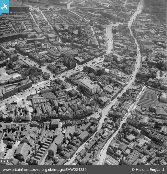
EAW024239 ENGLAND (1949). Humberstone Gate, Charles Street and the city centre, Leicester, 1949
© Copyright OpenStreetMap contributors and licensed by the OpenStreetMap Foundation. 2024. Cartography is licensed as CC BY-SA.
Nearby Images (28)
EAW024239

EAW024244

EPW018422

EAW024243

EAW024242

EPW055011

EAW051834

EPW018412

EPW047643

EAW051831

EPW047645

EPW047641

EPW055006

EPW020895

EPW018431

EAW024240

EPW018433

EPW061213

EPW018436

EPW020892

EPW018421

EPW055009

EAW052680
 Factory on Charles Street, Leicester, 1953. This image was marked by Aerofilms Ltd for photo editing.")
EAW052674
 Factory on Charles Street, St George's Church and Rutland Street, Leicester, 1953. This image was marked by Aerofilms Ltd for photo editing.")
EPW061211

EAW052676
 Factory on Charles Street and St George's Church, Leicester, 1953. This image was marked by Aerofilms Ltd for photo editing.")
EAW052675
 Factory on Charles Street, Leicester, 1953. This image was marked by Aerofilms Ltd for photo editing.")
EAW052679
 Factory on Charles Street, Leicester, 1953. This image was marked by Aerofilms Ltd for photo editing.")
Details
| Title | [EAW024239] Humberstone Gate, Charles Street and the city centre, Leicester, 1949 |
| Reference | EAW024239 |
| Date | 27-June-1949 |
| Link | |
| Place name | LEICESTER |
| Parish | |
| District | |
| Country | ENGLAND |
| Easting / Northing | 458882, 304605 |
| Longitude / Latitude | -1.1298239095383, 52.635644679391 |
| National Grid Reference | SK589046 |
Pins
 Class31 |
Tuesday 5th of May 2015 12:55:07 PM | |
Class31 |
Tuesday 5th of May 2015 12:52:59 PM | |
Class31 |
Tuesday 5th of May 2015 12:51:24 PM | |
Class31 |
Tuesday 5th of May 2015 12:48:13 PM |