
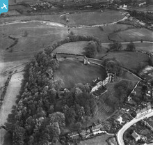
EAW004996 ENGLAND (1947). Tutbury Castle, Tutbury, 1947. This image has been produced from a print.

© Copyright OpenStreetMap contributors and licensed by the OpenStreetMap Foundation. 2024. Cartography is licensed as CC BY-SA.
Nearby Images (5)
EAW004996

EAW004995

EAW004997

EAW004998

EAW004999

Details
| Title | [EAW004996] Tutbury Castle, Tutbury, 1947. This image has been produced from a print. |
| Reference | EAW004996 |
| Date | 7-May-1947 |
| Link | |
| Place name | TUTBURY |
| Parish | TUTBURY |
| District | |
| Country | ENGLAND |
| Easting / Northing | 420931, 329175 |
| Longitude / Latitude | -1.6890899092665, 52.859331898665 |
| National Grid Reference | SK209292 |
Pins
 bescotbeast |
Friday 19th of September 2014 12:04:26 AM | |
bescotbeast |
Friday 19th of September 2014 12:03:28 AM | |
bescotbeast |
Thursday 18th of September 2014 11:51:57 PM | |
bescotbeast |
Thursday 18th of September 2014 11:44:07 PM |
User Comment Contributions
 Tutbury Signal box and Tutbury Yard signal boxes both of which are McKenzie and Holland type 1 |
bescotbeast |
Thursday 18th of September 2014 11:49:49 PM |


