
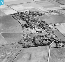
EAW004741 ENGLAND (1947). The village, Ickham, 1947

© Copyright OpenStreetMap contributors and licensed by the OpenStreetMap Foundation. 2024. Cartography is licensed as CC BY-SA.
Nearby Images (3)
EAW004741

EAW004740

EAW004739

Details
| Title | [EAW004741] The village, Ickham, 1947 |
| Reference | EAW004741 |
| Date | 26-April-1947 |
| Link | |
| Place name | ICKHAM |
| Parish | ICKHAM AND WELL |
| District | |
| Country | ENGLAND |
| Easting / Northing | 622132, 158174 |
| Longitude / Latitude | 1.1854317248657, 51.278821939633 |
| National Grid Reference | TR221582 |
Pins
 Matt Aldred edob.mattaldred.com |
Tuesday 24th of November 2020 11:31:55 PM | |
 Sparky |
Tuesday 4th of July 2017 09:51:23 PM | |
Sparky |
Tuesday 4th of July 2017 09:50:56 PM | |
Sparky |
Tuesday 4th of July 2017 09:48:04 PM | |
Sparky |
Tuesday 4th of July 2017 09:46:58 PM | |
Sparky |
Tuesday 4th of July 2017 09:45:43 PM | |
Sparky |
Tuesday 4th of July 2017 09:44:25 PM | |
Sparky |
Tuesday 4th of July 2017 09:42:54 PM | |
cptpies |
Thursday 12th of December 2013 01:56:58 PM |
User Comment Contributions
 Type 24 pillbox, Ickham. |
cptpies |
Thursday 19th of December 2013 02:15:22 PM |


