
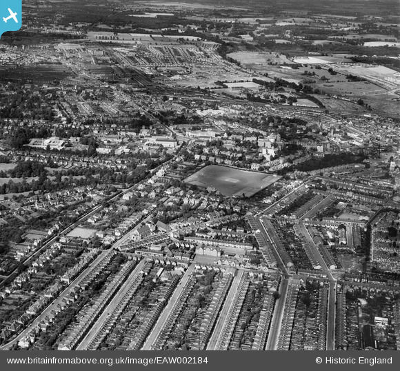
EAW002184 ENGLAND (1946). Sports Ground off Cassio Road and the town, Watford, from the south-west, 1946
© Copyright OpenStreetMap contributors and licensed by the OpenStreetMap Foundation. 2024. Cartography is licensed as CC BY-SA.
Nearby Images (3)
EAW002184

EPW019305

EAW026499

Details
| Title | [EAW002184] Sports Ground off Cassio Road and the town, Watford, from the south-west, 1946 |
| Reference | EAW002184 |
| Date | 15-August-1946 |
| Link | |
| Place name | WATFORD |
| Parish | |
| District | |
| Country | ENGLAND |
| Easting / Northing | 510178, 196198 |
| Longitude / Latitude | -0.40716340335487, 51.653295497588 |
| National Grid Reference | TQ102962 |
Pins
 John Swain |
Monday 2nd of September 2013 11:58:58 AM | |
John Swain |
Monday 2nd of September 2013 08:56:17 AM | |
I remember attending a meeting in St.Michael's Church Hall in April 1958, along with nearly 400 other cricket enthusiasts, to hear an illustrated lecture given by Trevor Bailey (Essex & England), assisted by Surrey & England pace bowler, Peter Loader, on the MCC tour of South Africa in 1956/57. Brilliant stuff, to be sure! |
John Swain |
Monday 2nd of September 2013 12:03:20 PM |
John Swain |
Monday 2nd of September 2013 08:37:50 AM | |
John Swain |
Monday 2nd of September 2013 08:36:26 AM | |
John Swain |
Monday 2nd of September 2013 08:35:35 AM | |
John Swain |
Monday 2nd of September 2013 08:34:32 AM | |
John Swain |
Monday 2nd of September 2013 08:33:48 AM | |
John Swain |
Monday 2nd of September 2013 08:33:11 AM | |
John Swain |
Monday 2nd of September 2013 08:30:16 AM | |
No.17 Cassiobury Park Avenue was demolished by a high explosive device on October 31, 1940, but there were no fatalities. |
John Swain |
Monday 2nd of September 2013 12:12:39 PM |
John Swain |
Monday 2nd of September 2013 08:29:28 AM | |
John Swain |
Monday 2nd of September 2013 08:28:47 AM | |
John Swain |
Monday 2nd of September 2013 08:27:40 AM | |
John Swain |
Monday 2nd of September 2013 08:26:10 AM | |
John Swain |
Monday 2nd of September 2013 08:24:52 AM | |
 ian |
Sunday 25th of August 2013 11:18:00 AM | |
ian |
Sunday 25th of August 2013 11:16:07 AM | |
ian |
Sunday 25th of August 2013 11:13:31 AM | |
ian |
Sunday 25th of August 2013 11:11:44 AM | |
ian |
Sunday 25th of August 2013 11:10:25 AM | |
ian |
Sunday 25th of August 2013 11:08:05 AM | |
ian |
Sunday 25th of August 2013 11:06:35 AM | |
ian |
Sunday 25th of August 2013 11:05:53 AM | |
ian |
Sunday 25th of August 2013 11:04:39 AM |
User Comment Contributions
Much of the foreground and middle distance in this urban scene of West Watford consisted of the Harwoods Farm Estate until the end of the 19th century. In 1902, Watford's westerly extent terminated at Harwoods Road, but the next decade saw the sale of further parcels of land for housing, so that most of the streets indicated here had been laid out and sewered by the outbreak of war in August 1914. |
John Swain |
Monday 2nd of September 2013 12:07:44 PM |
 A splendid image of Watford, looking north-east from West Watford just a year after the end of the Second World War, when the town's population had topped 65,000. Despite experiencing bomb damage, both from high explosives and incendiaries, throughout the hostilities, this part of the urban area appears to be relatively intact. |
John Swain |
Monday 2nd of September 2013 09:04:06 AM |


