
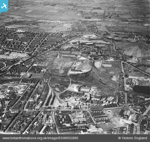
EAW001885 ENGLAND (1946). The Sneyd Colliery and Brick Works, Burslem, 1946
© Copyright OpenStreetMap contributors and licensed by the OpenStreetMap Foundation. 2024. Cartography is licensed as CC BY-SA.
Nearby Images (20)
EAW001885

EAW001878

EAW001882

EAW001883

EPW034084

EAW001877

EAW001884

EAW001879

EPW034089

EAW001876

EPW034094

EAW001881

EPW034086

EPW034091

EAW038491

EPW034085

EAW038486

EPW034087

EAW038487

EAW038485

Details
| Title | [EAW001885] The Sneyd Colliery and Brick Works, Burslem, 1946 |
| Reference | EAW001885 |
| Date | 12-July-1946 |
| Link | |
| Place name | BURSLEM |
| Parish | |
| District | |
| Country | ENGLAND |
| Easting / Northing | 387612, 349758 |
| Longitude / Latitude | -2.1847999756204, 53.044642515434 |
| National Grid Reference | SJ876498 |
Pins
 bescotbeast |
Monday 20th of November 2023 05:51:00 PM | |
bescotbeast |
Monday 20th of November 2023 05:50:17 PM | |
bescotbeast |
Monday 20th of November 2023 05:49:41 PM | |
bescotbeast |
Monday 20th of November 2023 05:46:37 PM | |
bescotbeast |
Monday 20th of November 2023 05:46:13 PM | |
 tunstall boy |
Monday 1st of May 2017 05:45:54 PM |


