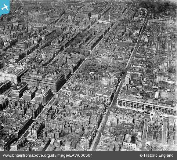
EAW000564 ENGLAND (1946). Gloucester Place, Baker Street and environs, Marylebone, 1946
© Copyright OpenStreetMap contributors and licensed by the OpenStreetMap Foundation. 2024. Cartography is licensed as CC BY-SA.
Nearby Images (44)
EAW000564

EPW021436

EAW052482

EPW055350

EAW052481

EAW050870

EAW050845

EAW050837

EAW000545

EPW011416

EAW050867

EPR000431

EPW021880

EAW029834

EPW021405

EPW045400

EPW006158

EPW044582

EPW021936

EAW021410

EAW053006

EPW044579

EPW060763

EPW005906

EPW035004

EAW021408

EAW021409

EPW021935

EPW035003

EPW035003
EPW006306

EAW046366

EPW044580

EAW050852

EAW000562

EAW000566

EAW021411

EAW050846

EAW050847

EPW005989

EPW060755

EPW007999

EPW007997

EPW007998

Details
| Title | [EAW000564] Gloucester Place, Baker Street and environs, Marylebone, 1946 |
| Reference | EAW000564 |
| Date | 9-May-1946 |
| Link | |
| Place name | MARYLEBONE |
| Parish | |
| District | |
| Country | ENGLAND |
| Easting / Northing | 528056, 181148 |
| Longitude / Latitude | -0.15432726069238, 51.514241957583 |
| National Grid Reference | TQ281811 |
Pins
 Class31 |
Wednesday 11th of March 2015 03:06:57 PM | |
Class31 |
Wednesday 11th of March 2015 09:02:50 AM | |
 David960 |
Thursday 19th of February 2015 08:01:58 PM | |
brianbeckett |
Wednesday 24th of September 2014 08:41:56 AM | |
brianbeckett |
Wednesday 24th of September 2014 08:38:36 AM | |
Class31 |
Thursday 31st of July 2014 06:01:19 PM | |
Class31 |
Thursday 31st of July 2014 06:00:48 PM | |
Class31 |
Thursday 31st of July 2014 05:59:42 PM | |
Class31 |
Thursday 31st of July 2014 05:55:59 PM | |
Note extensive damage at the rear of the building caused by a V2 rocket. |
brianbeckett |
Wednesday 24th of September 2014 08:39:59 AM |
Class31 |
Thursday 31st of July 2014 05:54:31 PM | |
Class31 |
Thursday 31st of July 2014 05:51:34 PM | |
Class31 |
Thursday 31st of July 2014 05:47:31 PM | |
Class31 |
Thursday 31st of July 2014 05:45:43 PM |