
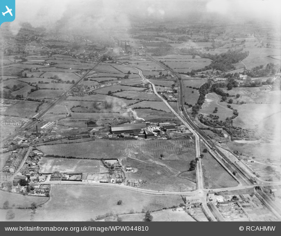
wpw044810 WALES (1934). View of Avondale Tinplate Co., Pontnewydd, oblique aerial view. 5"x4" black and white glass plate negative.
© Hawlfraint cyfranwyr OpenStreetMap a thrwyddedwyd gan yr OpenStreetMap Foundation. 2024. Trwyddedir y gartograffeg fel CC BY-SA.
Delweddau cyfagos (16)
WPW044806

WPW044807

WPW044808

WPW044809

WPW044810

WPW044811

WPW044812

WPW044813

WPW047021

WPW047022

WPW047023

WPW047024

WPW047025

WPW047026

WPW047027

WPW047028

Manylion
| Pennawd | [WPW044810] View of Avondale Tinplate Co., Pontnewydd, oblique aerial view. 5"x4" black and white glass plate negative. |
| Cyfeirnod | WPW044810 |
| Dyddiad | 1934 |
| Dolen | Coflein Archive Item 6369808 |
| Enw lle | |
| Plwyf | |
| Ardal | |
| Gwlad | WALES |
| Dwyreiniad / Gogleddiad | 329615, 196534 |
| Hydred / Lledred | -3.017744712628, 51.662709366501 |
| Cyfeirnod Grid Cenedlaethol | ST296965 |
Pinnau
 barney rubble |
Monday 1st of October 2018 09:08:15 PM | |
 Itsme |
Tuesday 27th of November 2012 01:37:28 PM | |
Itsme |
Tuesday 27th of November 2012 01:35:56 PM | |
barney rubble |
Tuesday 7th of August 2012 10:41:49 PM | |
Mike Rowney |
Saturday 7th of July 2012 03:27:02 PM | |
Mike Rowney |
Saturday 7th of July 2012 03:19:12 PM | |
Mike Rowney |
Saturday 7th of July 2012 03:16:57 PM | |
Mike Rowney |
Saturday 7th of July 2012 03:15:10 PM | |
Dadoze |
Wednesday 4th of July 2012 07:32:12 PM | |
Dadoze |
Wednesday 4th of July 2012 07:31:38 PM | |
Dadoze |
Wednesday 4th of July 2012 07:30:51 PM | |
Dadoze |
Wednesday 4th of July 2012 07:29:53 PM | |
Dadoze |
Wednesday 4th of July 2012 07:29:20 PM | |
Dadoze |
Wednesday 4th of July 2012 07:28:32 PM | |
Dadoze |
Wednesday 4th of July 2012 07:27:55 PM |


