
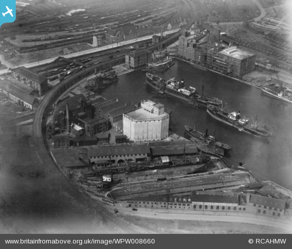
wpw008660 WALES (1923). View of Cardiff West Bute Dock showing general view of Butetown, oblique aerial view. 5"x4" black and white glass plate negative.
© Hawlfraint cyfranwyr OpenStreetMap a thrwyddedwyd gan yr OpenStreetMap Foundation. 2024. Trwyddedir y gartograffeg fel CC BY-SA.
Delweddau cyfagos (48)
WPW001000

WPW001001

WPW001002

WPW001003

WPW001004

WPW001008

WPW001009

WPW001010

WPW001014

WPW001035

WPW016914

WPW016915

WPW016916

WPW016917

WPW016918

WPW016919

WPW016920

WPW029422

WPW029423

WPW029424

WPW029425

WPW029427

WPW029429

WPW041787

WPW041788

WPW041789

WPW041790

WPW041791

WPW041792

WPW041793

WPW041794

WPW041795

WPW052624

WPW052659

WPW052660

WPW052661

WPW052662

WPW052663

WPW052664

WPW054861

WPW054863

WPW054864

WPW054865

WPW055450

WPW055451

WPW055452

WPW055453

WPW055454

Manylion
| Pennawd | [WPW008660] View of Cardiff West Bute Dock showing general view of Butetown, oblique aerial view. 5"x4" black and white glass plate negative. |
| Cyfeirnod | WPW008660 |
| Dyddiad | 1923 |
| Dolen | Coflein Archive Item 6370388 |
| Enw lle | |
| Plwyf | |
| Ardal | |
| Gwlad | WALES |
| Dwyreiniad / Gogleddiad | 318170, 176360 |
| Hydred / Lledred | -3.1785006478589, 51.479784917149 |
| Cyfeirnod Grid Cenedlaethol | ST182764 |
Pinnau
 MB |
Sunday 21st of August 2016 12:33:17 PM | |
I would suggest it's Elisabeth Maersk. There have been at least 2 vessels of that name so it runs in the company and could have been in use at that time. |
Brightonboy |
Friday 30th of September 2016 08:22:50 AM |
MB |
Sunday 21st of August 2016 12:31:13 PM | |
MB |
Sunday 21st of August 2016 12:30:25 PM | |
MB |
Sunday 21st of August 2016 12:28:32 PM | |
MB |
Sunday 21st of August 2016 12:27:51 PM | |
MB |
Sunday 21st of August 2016 12:27:30 PM | |
 Class31 |
Tuesday 29th of July 2014 03:42:17 PM |
Cyfraniadau Grŵp
This photograph is actually of the Bute East Dock (not West Dock) The sweeping railway line is of the Bute Viaduct (TVR) and the "small" building at the head of the dock (originally a bonded warehouse I believe) still exists as offices/flats. The Junction canal connection can just be seen to the top left of the East Dock joining it to the West Dock. the West Dock was disused and filled in during the 1960s. The area to the north of Tyndall Street ( the white line at the top of the photo) is/was an area to be called Newtown, yet to be developed in this photo. Now again in 2013 it is being flattened and re-developed. Butetown, not actually shown is to the west and south of this photo. |
Magnidec |
Sunday 24th of February 2013 07:27:35 PM |


