
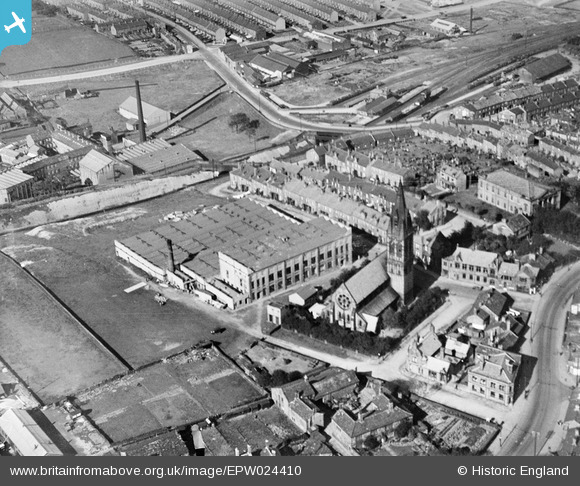
epw024410 ENGLAND (1928). Westcroft Mill and St John the Evangelist's Church, Great Horton, 1928
© Hawlfraint cyfranwyr OpenStreetMap a thrwyddedwyd gan yr OpenStreetMap Foundation. 2024. Trwyddedir y gartograffeg fel CC BY-SA.
Delweddau cyfagos (11)
EPW024410

EPW052161

EAW009135

EAW009132

EAW009130

EAW009136

EAW009134

EAW009131

EAW009128

EAW009133

EAW009129

Manylion
| Pennawd | [EPW024410] Westcroft Mill and St John the Evangelist's Church, Great Horton, 1928 |
| Cyfeirnod | EPW024410 |
| Dyddiad | September-1928 |
| Dolen | |
| Enw lle | GREAT HORTON |
| Plwyf | |
| Ardal | |
| Gwlad | ENGLAND |
| Dwyreiniad / Gogleddiad | 414145, 431676 |
| Hydred / Lledred | -1.7853132733278, 53.781003352956 |
| Cyfeirnod Grid Cenedlaethol | SE141317 |
Pinnau
Cyfraniadau Grŵp
Corn Mill Lane runs off the pic centre left now over a narrow railway bridge. The old corn mill was below the level of the railway and originated in the 1300's (Cudworth, Rambles around Horton) |
 chrisrob |
Sunday 14th of May 2017 05:08:15 PM |
In the top right is Great Horton railway station and goods yard which closed to passengers in 1955 and to goods in 1965. The road that crosses the railway is Beckside Road. |
AJ427 |
Wednesday 27th of June 2012 04:42:37 PM |


