
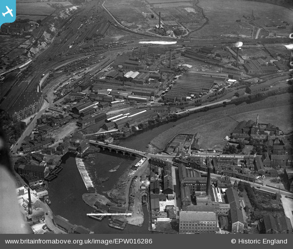
epw016286 ENGLAND (1926). Wakefield Bridge and factories beside the River Calder, Wakefield, 1926
© Hawlfraint cyfranwyr OpenStreetMap a thrwyddedwyd gan yr OpenStreetMap Foundation. 2024. Trwyddedir y gartograffeg fel CC BY-SA.
Delweddau cyfagos (14)
EPW016286

EPW032578

EPW016291

EPW032577

EPW032575

EAW002603

EAW003092

EAW002605

EAW002600

EAW002602

EAW002601

EPW032576

EPW032574

EPW032579

Manylion
| Pennawd | [EPW016286] Wakefield Bridge and factories beside the River Calder, Wakefield, 1926 |
| Cyfeirnod | EPW016286 |
| Dyddiad | 14-July-1926 |
| Dolen | |
| Enw lle | WAKEFIELD |
| Plwyf | |
| Ardal | |
| Gwlad | ENGLAND |
| Dwyreiniad / Gogleddiad | 433912, 420121 |
| Hydred / Lledred | -1.4865746571894, 53.676225852998 |
| Cyfeirnod Grid Cenedlaethol | SE339201 |
Pinnau
 Pete |
Thursday 18th of August 2022 10:16:40 PM | |
 ncbnik |
Monday 25th of April 2016 06:37:57 PM | |
 sirdouglas |
Tuesday 24th of March 2015 09:07:25 PM | |
Ray Shill |
Saturday 30th of August 2014 02:12:30 PM | |
This photo shows the Chantry on the bridge over the River Calder at the Kirkgate end of Wakefield. Forget age of this Chantry but I believe it has been removed from the original position - I could be wrong - it is many years since living in Yorkshire left there in 1965 - but Sandal was my birthplace. If you zoom left the railway at Kirkgate Station becomes visible very often used personally. Caldervale |
Caldervale |
Sunday 25th of January 2015 01:13:35 PM |
Ray Shill |
Saturday 30th of August 2014 02:11:59 PM | |
Ray Shill |
Saturday 30th of August 2014 02:10:36 PM |
Cyfraniadau Grŵp
Lower left corner of photo Kirkgate Station. The nearest platform is the Up direction. Rail tracks between the two platforms, the Down platform visible on the left side of photo. A track divergence - one leads almost straightforward towards Normanton, the curving route to the right leads to the Goole Branch. In between the straight line & the curve some sidings noticed. Two sidings actually one is Wakefield Exchange sidings, the other to the right of those is the carriage siding with carriage sheds. On the right of those sheds is Witham's sidings with vehicles on the buffered roads These sidings on the Goole Branch. The Junction where lines diverge straight or to right just beyond end of Kirkgate station is Wakefield East Junction (a large signal box) Next box is Whithams with line forward over rail bridge & River Calder. A signal box visible aptly named Calder Bridge was the exit off Wakefield Motive Power Depot (25A LMS 56A BR) The next signal box down the Goole Branch was Oakenshaw Jct where engines were placed on Wakefield M.P.D. or took a right hand junction onto the old Midland route from Normanton to Sheffield. Back to Whithams from Calder Bridge. A right hand junction to Turners Lane formed a triangle with Wakefield East Some sidings existed between Whithams & Turners Lane from Turners Lane forward Lockes Sidings then Goose Hill Junction (traffic to & from Midland Route joined here)and forward to Normanton, Leeds or Castleford to York from Normanton. |
Caldervale |
Saturday 24th of January 2015 04:03:13 PM |


