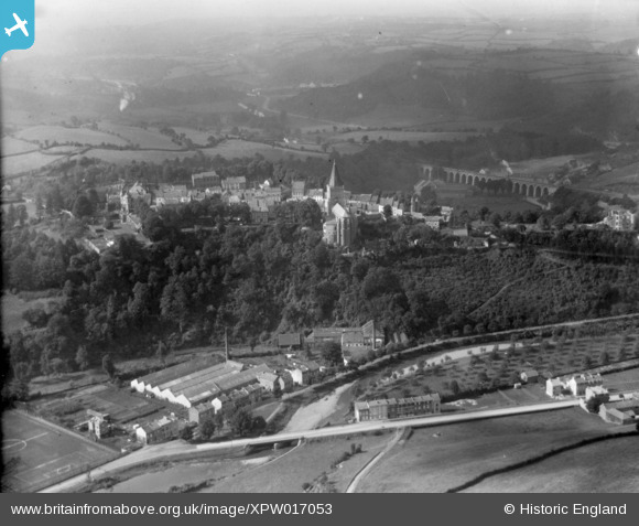
XPW017053 (1926) [Unlocated]. Unlocated, 1926.

© Hawlfraint cyfranwyr OpenStreetMap a thrwyddedwyd gan yr OpenStreetMap Foundation. 2024. Trwyddedir y gartograffeg fel CC BY-SA.

Delweddau cyfagos (48)

EPW000143
  0° 0m
EPW000667
  0° 0m
EPW005260
  0° 0m
EPW006389
  0° 0m
EPW007181
  0° 0m
EPW015853
  0° 0m
EPW015854
  0° 0m
EPW015855
  0° 0m
EPW016012
  0° 0m
EPW016510
  0° 0m
EPW016641
  0° 0m
EPW017028
  0° 0m
EPW017029
  0° 0m
EPW017136
  0° 0m
SAW003585
  0° 0m
SAW003586
  0° 0m
SAW009337
  0° 0m
SAW009800
  0° 0m
SAW009801
  0° 0m
SAW009802
  0° 0m
SAW010734
  0° 0m
SAW014737
  0° 0m
SAW017926
  0° 0m
SAW017927
  0° 0m
SAW032504
  0° 0m
SPW020275
  0° 0m
SPW020280
  0° 0m
SPW020281
  0° 0m
SPW020284
  0° 0m
SPW020632
  0° 0m
SPW020633
  0° 0m
SPW027083
  0° 0m
SPW049776
  0° 0m
SPW049777
  0° 0m
SPW049779
  0° 0m
SPW049783
  0° 0m
SPW049791
  0° 0m
SPW049798
  0° 0m
SPW049801
  0° 0m
SPW049827
  0° 0m
SPW049828
  0° 0m
SPW049831
  0° 0m
SPW049832
  0° 0m
SPW049834
  0° 0m
SPW049948
  0° 0m
SPW049949
  0° 0m
SPW051009
  0° 0m
SPW062638
  0° 0m

Manylion

Pennawd [XPW017053] Unlocated, 1926.
Cyfeirnod XPW017053
Dyddiad 1926
Dolen
Enw lle
Plwyf
Ardal
Gwlad
Dwyreiniad / Gogleddiad 0, 0
Hydred / Lledred ,
Cyfeirnod Grid Cenedlaethol

Pinnau

Liege to Aachen railway line.

Class31
Saturday 4th of October 2014 01:53:56 PM
Sur Les Remparts / Rue Oscar Thimus. The entrance into the Limburg Fortress Ruins. The first castle on top of the massive rock above the Vesdre was constructed by Waleran, Duke of Limburg, in 1033. It possessed five big round towers. Impregnable fortress, Limbourg resisted a one-month siege by the troops of Emperor Henry IV in 1101.

Ray Flack
Saturday 4th of October 2014 01:04:28 PM
Great photos - you must have been waiting for this photo to be published!

Class31
Saturday 4th of October 2014 01:56:37 PM
"An Overview showing: "St Georges Church" and the ruins of "Limburge Fortress". "Limburge Fortress". Destroyed by a fire in 1504, the castle was reconstructed between 1519 and 1530, and adapted to the technological advances in artillery. Limbourg was besieged many times between the 16th and 18th centuries, notably in 1578 by the Spaniards, in 1632 by the Dutch, in 1635 by the Spaniards again, in 1675 by Louis XIV (who razed most of the town), in 1703 by the Anglo-Dutch under the command of the Duke of Marlborough, and in 1715 by the Austrians. The castle left in ruins by all these sieges, was completely dismantled in 1781. Julien d'Andrimont acquires the ruins in the late 19th century and erects a romantic castle, destroyed by the Germans in 1914. After WWI, the site is purchased by architect Jean Lejaer, then by Baron Jean Poswick, who built the residential castle that stands today.

Ray Flack
Saturday 4th of October 2014 12:39:26 PM
Pal St-Georges. Picture taken at the junction with: "Pl Saint-Georges", "Hors Le Ports", "Sur Les Remparts" and "Tilleul".

Ray Flack
Saturday 4th of October 2014 12:19:08 PM
"St Georges Church".

Ray Flack
Saturday 4th of October 2014 12:05:18 PM
Sur Les Remports.

Ray Flack
Saturday 4th of October 2014 12:04:14 PM
I think that this may have been a "Gate House" when the image is blown up to max you can see "Two Spires" with what looks like an entrance in the middle. Todays image only shows one Spire when entering "Pl, Saint Georges" from "Hors Les Portes".

Ray Flack
Saturday 4th of October 2014 12:02:49 PM
Hors Les Portes.

Ray Flack
Saturday 4th of October 2014 11:45:29 AM
football ground

bescotbeast
Saturday 4th of October 2014 09:49:04 AM
Is this a ruined house (mansion) leftover from the 1914-18 War

Maurice
Saturday 4th of October 2014 09:02:03 AM

Cyfraniadau Grŵp

France?

TOM
Saturday 4th of October 2014 12:08:12 PM
This is the same location as XPW017080 which is identified as General View, Limburg, Liege, Belgium, 1926. Oblique aerial photograph taken facing North/West. The viaduct and the church are the same!

Class31
Friday 3rd of October 2014 11:51:19 PM