
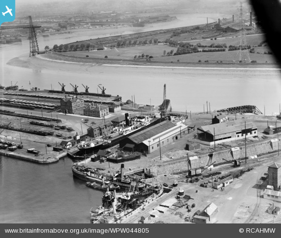
WPW044805 WALES (1934) [Unlocated]. View of a ship in dry dock, Newport, oblique aerial view. 5"x4" black and white glass plate negative.
© Hawlfraint cyfranwyr OpenStreetMap a thrwyddedwyd gan yr OpenStreetMap Foundation. 2024. Trwyddedir y gartograffeg fel CC BY-SA.
Delweddau cyfagos (48)
EPW000143

EPW000667

EPW005260

EPW006389
, 1921")
EPW007181

EPW015853

EPW015854

EPW015855

EPW016012

EPW016510

EPW016641

EPW017028

EPW017029

EPW017136

SAW003585

SAW003586

SAW009337

SAW009800

SAW009801

SAW009802

SAW010734

SAW014737

SAW017926

SAW017927

SAW032504

SPW020275

SPW020280

SPW020281

SPW020284

SPW020632

SPW020633

SPW027083

SPW049776

SPW049777

SPW049779

SPW049783

SPW049791

SPW049798

SPW049801

SPW049827

SPW049828

SPW049831

SPW049832

SPW049834

SPW049948

SPW049949

SPW051009

SPW062638

Manylion
| Pennawd | [WPW044805] View of a ship in dry dock, Newport, oblique aerial view. 5"x4" black and white glass plate negative. |
| Cyfeirnod | WPW044805 |
| Dyddiad | 1934 |
| Dolen | Coflein Archive Item 6369803 |
| Enw lle | |
| Plwyf | |
| Ardal | |
| Gwlad | WALES |
| Dwyreiniad / Gogleddiad | 0, 0 |
| Hydred / Lledred | -7.556448482059, 49.766185796754 |
| Cyfeirnod Grid Cenedlaethol | SV000000 |
Pinnau
Cyfraniadau Grŵp
This Bailey's dry dock Newport with the second dry dock owned by the dock company alongside. The dry dock with the ship is not a lock, but I think it may have started life as an entrance to the docks from the river Usk, but I may be wrong on this as there are three possible sites still in existance for the entrance lock. The new lock when built was one of the longest in the UK over 1000 ft long with extra gate to reduce length when required. |
 Louis |
Thursday 19th of July 2012 12:02:51 PM |
Surely the vessel is in the lock that maintains the high level of the enclosed dock compared to the tidal fluctuations of the River Usk. The tide is out and the (wet) dock is high. It is called a ‘wet dock’ because it always had water in it, rather the than the ships sitting on their bottoms at low water. A dry dock would have been ‘blind’ at one end and would have probably had rather more working space. Good examples can be found in the collection of aerial pictures of Falmouth Docks. |
 Maurice |
Friday 13th of July 2012 08:57:15 AM |
This is an aerial photograph of the Alexandra Dock. The Transporter Bridge, on the bend of the river carried workers over the River Usk to the Lysaghts Steelworks on the right of the photo. Coronation Park is also this side of the River, below the Steelworks. On the distant left of the photo is the inlet or pill known as Pillgwennly and the entrance to the Old Town Dock. |
willtap |
Friday 13th of July 2012 12:46:17 AM |


