
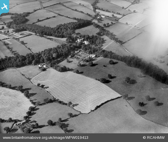
WPW019413 WALES (1927). View of Bronwylfa Hall, oblique aerial view. 5"x4" black and white glass plate negative.
© Hawlfraint cyfranwyr OpenStreetMap a thrwyddedwyd gan yr OpenStreetMap Foundation. 2024. Trwyddedir y gartograffeg fel CC BY-SA.
Delweddau cyfagos (10)
WPW019410

WPW019411

WPW019412

WPW019413

WPW019414

WPW019415

WPW019416

WPW019418

WPW019420

WPW019421

Manylion
| Pennawd | [WPW019413] View of Bronwylfa Hall, oblique aerial view. 5"x4" black and white glass plate negative. |
| Cyfeirnod | WPW019413 |
| Dyddiad | 1927 |
| Dolen | Coflein Archive Item 6378317 |
| Enw lle | |
| Plwyf | |
| Ardal | |
| Gwlad | WALES |
| Dwyreiniad / Gogleddiad | 328290, 348280 |
| Hydred / Lledred | -3.06931786492, 53.02669212835 |
| Cyfeirnod Grid Cenedlaethol | SJ283483 |
Pinnau
Cyfraniadau Grŵp
This is a positive identification of Bronwylfa Hall about two miles West of Rhostyllen, Wrexham. Shot is taken looking North West over Lower Farm and Tan-y-lan with Bronwylfa Hall in centre shot. Beyond is Cae Glas. Gronwen Filters are on the left. Grid ReferenceSJ 28330 48255. |
 Class31 |
Tuesday 17th of July 2012 10:02:34 AM |


