
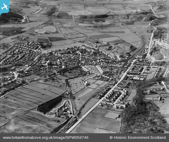
SPW056746 SCOTLAND (1938). Kilsyth, general view, showing Burngreen Park and Stirling Road. An oblique aerial photograph taken facing south-west.
© Hawlfraint cyfranwyr OpenStreetMap a thrwyddedwyd gan yr OpenStreetMap Foundation. 2024. Trwyddedir y gartograffeg fel CC BY-SA.
Delweddau cyfagos (6)
SPW056746

SPW033633

SPW056744

SPW033632

SPW033631

SPW056745

Manylion
| Pennawd | [SPW056746] Kilsyth, general view, showing Burngreen Park and Stirling Road. An oblique aerial photograph taken facing south-west. |
| Cyfeirnod | SPW056746 |
| Dyddiad | 1938 |
| Dolen | Canmore Collection item 1258201 |
| Enw lle | |
| Plwyf | KILSYTH (NORTH LANARKSHIRE) |
| Ardal | CUMBERNAULD AND KILSYTH |
| Gwlad | SCOTLAND |
| Dwyreiniad / Gogleddiad | 271910, 677876 |
| Hydred / Lledred | -4.0529170532704, 55.976797773905 |
| Cyfeirnod Grid Cenedlaethol | NS719779 |
Pinnau
 almac |
Sunday 30th of June 2013 08:35:34 PM | |
almac |
Sunday 30th of June 2013 08:34:28 PM | |
almac |
Sunday 30th of June 2013 08:32:49 PM | |
Thistledown |
Tuesday 17th of July 2012 04:15:27 AM | |
Thistledown |
Tuesday 17th of July 2012 04:14:20 AM | |
Thistledown |
Tuesday 17th of July 2012 04:13:45 AM | |
Thistledown |
Tuesday 17th of July 2012 04:12:04 AM | |
Thistledown |
Tuesday 17th of July 2012 04:11:14 AM | |
Thistledown |
Tuesday 17th of July 2012 04:09:58 AM | |
Thistledown |
Tuesday 17th of July 2012 04:09:24 AM | |
patoflarbert |
Monday 2nd of July 2012 07:58:28 AM | |
patoflarbert |
Monday 2nd of July 2012 07:56:35 AM | |
patoflarbert |
Monday 2nd of July 2012 07:52:28 AM | |
The Academy also had temporary accommodation in " huts" out past St Patricks |
almac |
Saturday 17th of August 2013 10:02:39 PM |
patoflarbert |
Monday 2nd of July 2012 07:35:24 AM | |
Andy N.C. |
Tuesday 26th of June 2012 10:14:24 PM |
Cyfraniadau Grŵp
Quarry. Originally site for 'Waterfall Village', housing development. Now a conventional housing estate. |
John Mitchell |
Thursday 23rd of October 2014 02:24:57 PM |
 Haugh Pit |
cell |
Tuesday 26th of February 2013 09:09:18 PM |


