
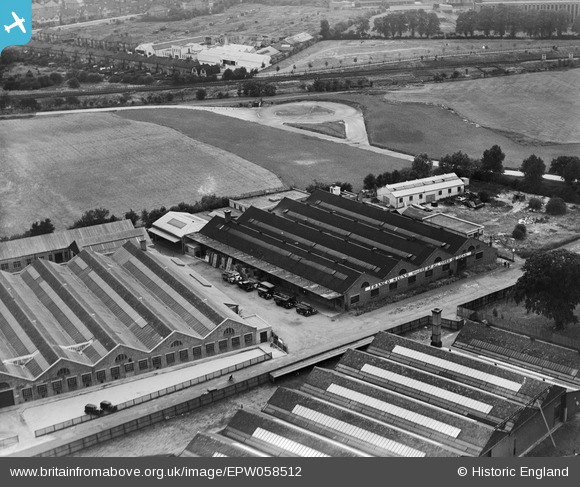
EPW058512 ENGLAND (1938). The Franco Signs Works on Aerodrome Road, Colindale, 1938
© Hawlfraint cyfranwyr OpenStreetMap a thrwyddedwyd gan yr OpenStreetMap Foundation. 2024. Trwyddedir y gartograffeg fel CC BY-SA.
Delweddau cyfagos (21)
EPW058512

EPW058514

EPW058513

EPW025849
 flying over Hendon Country Club, 1929")
EPW008852

EPR000650

EPW016610

EPW008757

EPW016609

EPW038689

EPW016611

EPW016607

EPW006132

EPW016605

EPW038688

EPW016612

EPW008760

EPW016606

EPW008750

EPW008751

EPW010855

Manylion
| Pennawd | [EPW058512] The Franco Signs Works on Aerodrome Road, Colindale, 1938 |
| Cyfeirnod | EPW058512 |
| Dyddiad | 5-August-1938 |
| Dolen | |
| Enw lle | COLINDALE |
| Plwyf | |
| Ardal | |
| Gwlad | ENGLAND |
| Dwyreiniad / Gogleddiad | 521713, 189926 |
| Hydred / Lledred | -0.24266300160205, 51.594542782561 |
| Cyfeirnod Grid Cenedlaethol | TQ217899 |
Pinnau
 ken |
Wednesday 14th of October 2015 08:42:24 PM | |
ken |
Wednesday 14th of October 2015 08:40:22 PM | |
ken |
Saturday 15th of August 2015 03:32:09 PM | |
ken |
Saturday 15th of August 2015 03:30:33 PM | |
ken |
Saturday 15th of August 2015 03:28:45 PM | |
ken |
Saturday 15th of August 2015 03:28:03 PM | |
ken |
Saturday 15th of August 2015 03:25:06 PM | |
ken |
Saturday 15th of August 2015 03:23:47 PM | |
ken |
Saturday 15th of August 2015 03:22:51 PM | |
Brightonboy |
Wednesday 13th of August 2014 09:50:56 PM | |
 Class31 |
Monday 10th of March 2014 08:28:00 PM | |
Class31 |
Monday 10th of March 2014 08:26:36 PM | |
Class31 |
Monday 10th of March 2014 08:23:07 PM | |
My guess would be for bus driver training. |
John Wass |
Wednesday 13th of August 2014 09:20:49 PM |
This was one of two skid pans later used by the Met Police Driving School which was sited here. However, in 1938 I am not sure if this establishment existed on the site. It might have been a legacy of the nearby W C Gaunt, Packard Motors site. |
The Laird |
Saturday 10th of October 2015 08:28:40 PM |
Class31 |
Monday 10th of March 2014 08:21:48 PM | |
Class31 |
Monday 10th of March 2014 08:21:21 PM | |
Class31 |
Monday 10th of March 2014 08:19:27 PM |
Cyfraniadau Grŵp
View looking south west. |
Class31 |
Monday 10th of March 2014 08:29:14 PM |


