
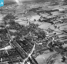
EPW058405 ENGLAND (1938). The town, Stone, from the north-west, 1938

© Hawlfraint cyfranwyr OpenStreetMap a thrwyddedwyd gan yr OpenStreetMap Foundation. 2024. Trwyddedir y gartograffeg fel CC BY-SA.
Delweddau cyfagos (6)
EPW058405

EPW020072

EPW026979

EPW020073

EPW053351

EPW026983

Manylion
| Pennawd | [EPW058405] The town, Stone, from the north-west, 1938 |
| Cyfeirnod | EPW058405 |
| Dyddiad | 28-July-1938 |
| Dolen | |
| Enw lle | STONE |
| Plwyf | STONE |
| Ardal | |
| Gwlad | ENGLAND |
| Dwyreiniad / Gogleddiad | 389874, 334274 |
| Hydred / Lledred | -2.1505717401621, 52.905485513586 |
| Cyfeirnod Grid Cenedlaethol | SJ899343 |
Pinnau
 bescotbeast |
Monday 28th of October 2013 04:47:33 AM | |
bescotbeast |
Monday 28th of October 2013 04:46:06 AM |
Cyfraniadau Grŵp
 view over Stone |
 Martin |
Monday 30th of December 2013 03:38:44 PM |
Meaford Crossing signal box, NSR type 1 design. |
bescotbeast |
Monday 9th of December 2013 11:26:46 PM |


