
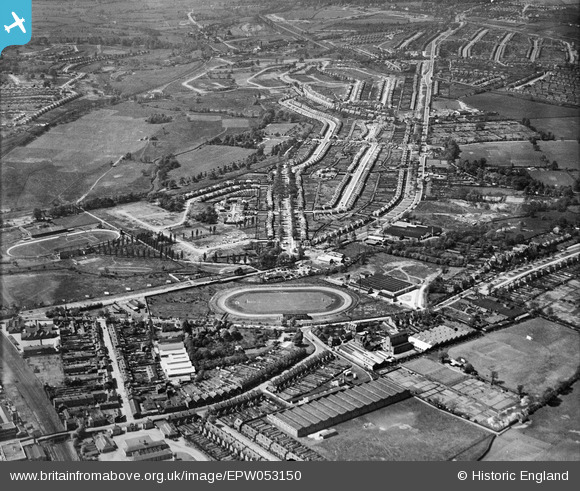
EPW053150 ENGLAND (1937). Perry Barr Stadium and the surrounding residential area, Perry Barr, 1937
© Hawlfraint cyfranwyr OpenStreetMap a thrwyddedwyd gan yr OpenStreetMap Foundation. 2024. Trwyddedir y gartograffeg fel CC BY-SA.
Manylion
| Pennawd | [EPW053150] Perry Barr Stadium and the surrounding residential area, Perry Barr, 1937 |
| Cyfeirnod | EPW053150 |
| Dyddiad | 19-May-1937 |
| Dolen | |
| Enw lle | PERRY BARR |
| Plwyf | |
| Ardal | |
| Gwlad | ENGLAND |
| Dwyreiniad / Gogleddiad | 406722, 291507 |
| Hydred / Lledred | -1.9009199454917, 52.521036215097 |
| Cyfeirnod Grid Cenedlaethol | SP067915 |
Pinnau
 Rekrap |
Wednesday 21st of April 2021 12:10:22 AM | |
Rob |
Friday 19th of February 2021 06:57:53 AM | |
 Andy Mabbett |
Wednesday 29th of April 2020 06:33:12 PM | |
Andy Mabbett |
Wednesday 29th of April 2020 06:27:03 PM | |
Andy Mabbett |
Wednesday 29th of April 2020 06:00:14 PM | |
Andy Mabbett |
Wednesday 29th of April 2020 05:57:16 PM | |
Andy Mabbett |
Wednesday 29th of April 2020 05:55:07 PM | |
Tony Oz |
Wednesday 26th of June 2019 01:38:01 PM | |
jp1945 |
Monday 26th of December 2016 04:31:41 PM | |
jp1945 |
Monday 26th of December 2016 04:24:46 PM | |
jp1945 |
Monday 26th of December 2016 04:20:54 PM | |
jp1945 |
Monday 26th of December 2016 04:18:44 PM | |
Griffin |
Friday 30th of October 2015 11:41:35 AM | |
Griffin |
Friday 30th of October 2015 11:40:09 AM | |
Griffin |
Friday 30th of October 2015 11:38:19 AM | |
Griffin |
Friday 30th of October 2015 11:33:31 AM | |
Griffin |
Friday 30th of October 2015 11:12:53 AM | |
Griffin |
Friday 30th of October 2015 11:09:42 AM | |
Griffin |
Thursday 29th of October 2015 06:49:17 PM | |
Griffin |
Thursday 29th of October 2015 06:47:36 PM | |
John S |
Monday 7th of July 2014 07:17:27 PM | |
John S |
Monday 7th of July 2014 07:16:37 PM | |
gerry-r |
Monday 16th of June 2014 12:52:57 AM | |
Alan R |
Friday 21st of March 2014 06:14:13 PM |


