
EPW047096 ENGLAND (1935). The Middlesex Hospital and surroundings, Marylebone, 1935

© Hawlfraint cyfranwyr OpenStreetMap a thrwyddedwyd gan yr OpenStreetMap Foundation. 2024. Trwyddedir y gartograffeg fel CC BY-SA.
Delweddau cyfagos (15)
EPW047096

EPW047094

EPW047095

EPW047093

EPW012738

EPW047097

EPW012751

EPW012749

EPW012736

EPW012750

EPW012737

EAW000537

EPW012735

EPW005130

EPW060756

Manylion
| Pennawd | [EPW047096] The Middlesex Hospital and surroundings, Marylebone, 1935 |
| Cyfeirnod | EPW047096 |
| Dyddiad | May-1935 |
| Dolen | |
| Enw lle | MARYLEBONE |
| Plwyf | |
| Ardal | |
| Gwlad | ENGLAND |
| Dwyreiniad / Gogleddiad | 529261, 181750 |
| Hydred / Lledred | -0.13674858583719, 51.519378099687 |
| Cyfeirnod Grid Cenedlaethol | TQ293818 |
Pinnau
 Kathy Emery |
Saturday 5th of March 2022 11:50:34 PM | |
Kea |
Saturday 15th of June 2013 06:44:47 PM |
Cyfraniadau Grŵp
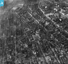 Empty site before Paramount Court is built (upper-right quadrant). |
Kea |
Saturday 15th of June 2013 06:45:57 PM |


