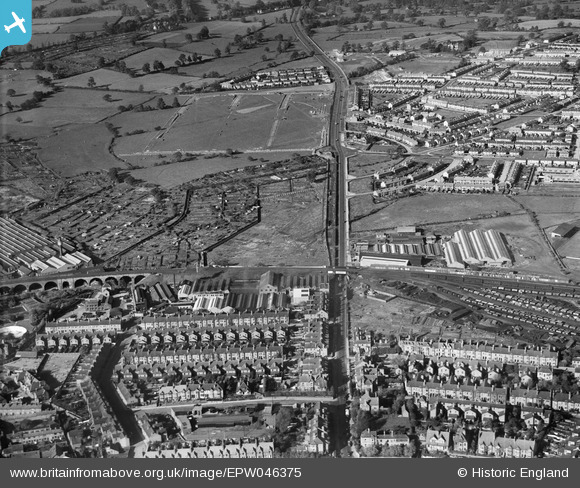
EPW046375 ENGLAND (1934). Alvis Motor Car and Engineering Works, housing development at Lammas Road and environs, Spon End, 1934
© Hawlfraint cyfranwyr OpenStreetMap a thrwyddedwyd gan yr OpenStreetMap Foundation. 2024. Trwyddedir y gartograffeg fel CC BY-SA.
Delweddau cyfagos (29)
Manylion
| Pennawd | [EPW046375] Alvis Motor Car and Engineering Works, housing development at Lammas Road and environs, Spon End, 1934 |
| Cyfeirnod | EPW046375 |
| Dyddiad | October-1934 |
| Dolen | |
| Enw lle | SPON END |
| Plwyf | |
| Ardal | |
| Gwlad | ENGLAND |
| Dwyreiniad / Gogleddiad | 432251, 279408 |
| Hydred / Lledred | -1.5258098065031, 52.41134438956 |
| Cyfeirnod Grid Cenedlaethol | SP323794 |
Pinnau
 SteveBo |
Saturday 24th of August 2013 04:41:27 PM | |
 SteveBo |
Saturday 24th of August 2013 04:40:27 PM | |
 SteveBo |
Saturday 24th of August 2013 04:39:56 PM | |
 SteveBo |
Saturday 24th of August 2013 04:38:55 PM | |
 SteveBo |
Saturday 24th of August 2013 04:38:15 PM | |
 SteveBo |
Saturday 24th of August 2013 04:37:38 PM | |
 SteveBo |
Saturday 24th of August 2013 04:36:54 PM | |
 SteveBo |
Saturday 24th of August 2013 04:36:20 PM |


![[EPW046375] Alvis Motor Car and Engineering Works, housing development at Lammas Road and environs, Spon End, 1934](http://britainfromabove.org.uk/sites/all/libraries/aerofilms-images/public/100x100/EPW/046/EPW046375.jpg)
![[EPW046376] Alvis Motor Car and Engineering Works, housing development at Lammas Road and environs, Spon End, 1934](http://britainfromabove.org.uk/sites/all/libraries/aerofilms-images/public/100x100/EPW/046/EPW046376.jpg)
![[EPW051456] The Alvis Car and Engineering Co Works, Spon End, 1936](http://britainfromabove.org.uk/sites/all/libraries/aerofilms-images/public/100x100/EPW/051/EPW051456.jpg)
![[EPW051459] The Alvis Car and Engineering Co Works and environs, Spon End, 1936](http://britainfromabove.org.uk/sites/all/libraries/aerofilms-images/public/100x100/EPW/051/EPW051459.jpg)
![[EPW044457] The Alvis Car and Engineering Works and allotment gardens off Holyhead Road, Coventry, 1934](http://britainfromabove.org.uk/sites/all/libraries/aerofilms-images/public/100x100/EPW/044/EPW044457.jpg)
![[EPW051461] The Alvis Car and Engineering Co Works and environs, Spon End, 1936](http://britainfromabove.org.uk/sites/all/libraries/aerofilms-images/public/100x100/EPW/051/EPW051461.jpg)
![[EPW051455] The Alvis Car and Engineering Co Works and environs, Spon End, 1936](http://britainfromabove.org.uk/sites/all/libraries/aerofilms-images/public/100x100/EPW/051/EPW051455.jpg)
![[EPW051462] The Alvis Car and Engineering Co Works and environs, Spon End, 1936](http://britainfromabove.org.uk/sites/all/libraries/aerofilms-images/public/100x100/EPW/051/EPW051462.jpg)
![[EPW051463] The Alvis Car and Engineering Co Works and environs, Spon End, 1936](http://britainfromabove.org.uk/sites/all/libraries/aerofilms-images/public/100x100/EPW/051/EPW051463.jpg)
![[EPW044453] The Alvis Car and Engineering Works, allotment gardens off Holyhead Road and environs, Coventry, 1934](http://britainfromabove.org.uk/sites/all/libraries/aerofilms-images/public/100x100/EPW/044/EPW044453.jpg)
![[EPW051467] The Alvis Car and Engineering Co Works, Spon End, 1936](http://britainfromabove.org.uk/sites/all/libraries/aerofilms-images/public/100x100/EPW/051/EPW051467.jpg)
![[EPW051457] The Alvis Car and Engineering Co Works and environs, Spon End, 1936](http://britainfromabove.org.uk/sites/all/libraries/aerofilms-images/public/100x100/EPW/051/EPW051457.jpg)
![[EPW051464] The Alvis Car and Engineering Co Works and environs, Spon End, 1936](http://britainfromabove.org.uk/sites/all/libraries/aerofilms-images/public/100x100/EPW/051/EPW051464.jpg)
![[EPW044455] The Alvis Car and Engineering Works and allotment gardens off Holyhead Road, Coventry, 1934](http://britainfromabove.org.uk/sites/all/libraries/aerofilms-images/public/100x100/EPW/044/EPW044455.jpg)
![[EPW044454] The Alvis Car and Engineering Works and allotment gardens off Holyhead Road, Coventry, 1934](http://britainfromabove.org.uk/sites/all/libraries/aerofilms-images/public/100x100/EPW/044/EPW044454.jpg)
![[EPW051460] The Alvis Car and Engineering Co Works and adjacent allotment gardens, Spon End, 1936](http://britainfromabove.org.uk/sites/all/libraries/aerofilms-images/public/100x100/EPW/051/EPW051460.jpg)
![[EPW051454] The Alvis Car and Engineering Co Works and environs, Spon End, 1936](http://britainfromabove.org.uk/sites/all/libraries/aerofilms-images/public/100x100/EPW/051/EPW051454.jpg)
![[EPW044451] The Alvis Car and Engineering Works, allotment gardens off Holyhead Road and environs, Coventry, 1934](http://britainfromabove.org.uk/sites/all/libraries/aerofilms-images/public/100x100/EPW/044/EPW044451.jpg)
![[EPW051466] The Alvis Car and Engineering Co Works and environs, Spon End, 1936](http://britainfromabove.org.uk/sites/all/libraries/aerofilms-images/public/100x100/EPW/051/EPW051466.jpg)
![[EPW046377] Alvis Motor Car and Engineering Works, housing development at Lammas Road and environs, Spon End, 1934](http://britainfromabove.org.uk/sites/all/libraries/aerofilms-images/public/100x100/EPW/046/EPW046377.jpg)
![[EPW044452] The Alvis Car and Engineering Works, allotment gardens off Holyhead Road and environs, Coventry, 1934](http://britainfromabove.org.uk/sites/all/libraries/aerofilms-images/public/100x100/EPW/044/EPW044452.jpg)
![[EPW051465] The Alvis Car and Engineering Co Works and environs, Spon End, 1936](http://britainfromabove.org.uk/sites/all/libraries/aerofilms-images/public/100x100/EPW/051/EPW051465.jpg)
![[EPW044456] The Alvis Car and Engineering Works, Coventry, 1934](http://britainfromabove.org.uk/sites/all/libraries/aerofilms-images/public/100x100/EPW/044/EPW044456.jpg)
![[EPW046374] Alvis Motor Car and Engineering Works and the Coventry Corporation Water Works, Spon End, 1934](http://britainfromabove.org.uk/sites/all/libraries/aerofilms-images/public/100x100/EPW/046/EPW046374.jpg)
![[EPW046379] Alvis Motor Car and Engineering Works, Spon End, 1934](http://britainfromabove.org.uk/sites/all/libraries/aerofilms-images/public/100x100/EPW/046/EPW046379.jpg)
![[EPW046373] Alvis Motor Car and Engineering Works and the Coventry Corporation Water Works, Spon End, 1934](http://britainfromabove.org.uk/sites/all/libraries/aerofilms-images/public/100x100/EPW/046/EPW046373.jpg)
![[EPW046378] Alvis Motor Car and Engineering Works and the Coventry Corporation Water Works, Spon End, 1934](http://britainfromabove.org.uk/sites/all/libraries/aerofilms-images/public/100x100/EPW/046/EPW046378.jpg)
![[EPW053106] The City, Coventry, from the west, 1937](http://britainfromabove.org.uk/sites/all/libraries/aerofilms-images/public/100x100/EPW/053/EPW053106.jpg)
![[EPW035780] Housing off Moseley Avenue, Barkers' Butts Lane and environs, Coventry, from the south-west, 1931](http://britainfromabove.org.uk/sites/all/libraries/aerofilms-images/public/100x100/EPW/035/EPW035780.jpg)


