
EPW042559 ENGLAND (1933) [Unlocated]. UNLOCATED
© Hawlfraint cyfranwyr OpenStreetMap a thrwyddedwyd gan yr OpenStreetMap Foundation. 2024. Trwyddedir y gartograffeg fel CC BY-SA.
Delweddau cyfagos (48)
EPW000143

EPW000667

EPW005260

EPW006389
, 1921")
EPW007181

EPW015853

EPW015854

EPW015855

EPW016012

EPW016510

EPW016641

EPW017028

EPW017029

EPW017136

SAW003585

SAW003586

SAW009337

SAW009800

SAW009801

SAW009802

SAW010734

SAW014737

SAW017926

SAW017927

SAW032504

SPW020275

SPW020280

SPW020281

SPW020284

SPW020632

SPW020633

SPW027083

SPW049776

SPW049777

SPW049779

SPW049783

SPW049791

SPW049798

SPW049801

SPW049827

SPW049828

SPW049831

SPW049832

SPW049834

SPW049948

SPW049949

SPW051009

SPW062638

Manylion
| Pennawd | [EPW042559] UNLOCATED |
| Cyfeirnod | EPW042559 |
| Dyddiad | July-1933 |
| Dolen | |
| Enw lle | |
| Plwyf | |
| Ardal | |
| Gwlad | ENGLAND |
| Dwyreiniad / Gogleddiad | 0, 0 |
| Hydred / Lledred | -7.556448482059, 49.766185796754 |
| Cyfeirnod Grid Cenedlaethol | SV000000 |
Pinnau
 Maz |
Wednesday 24th of January 2018 02:40:30 PM | |
 Class31 |
Monday 7th of October 2013 06:49:52 PM | |
Class31 |
Monday 7th of October 2013 06:36:23 PM | |
Class31 |
Monday 7th of October 2013 06:33:49 PM | |
Class31 |
Monday 7th of October 2013 06:31:15 PM | |
Chris Willis |
Monday 24th of June 2013 05:56:00 PM | |
This is The Waverley Line ex North British Railway and at the time of the photograph London & North Eastern Railway. The line ran from Edinburgh to Carlisle and closed on 6th January 1969. The line is to be partially reopened from Edinburgh to Tweedbank in 2015. |
Class31 |
Monday 7th of October 2013 06:57:15 PM |
Cyfraniadau Grŵp
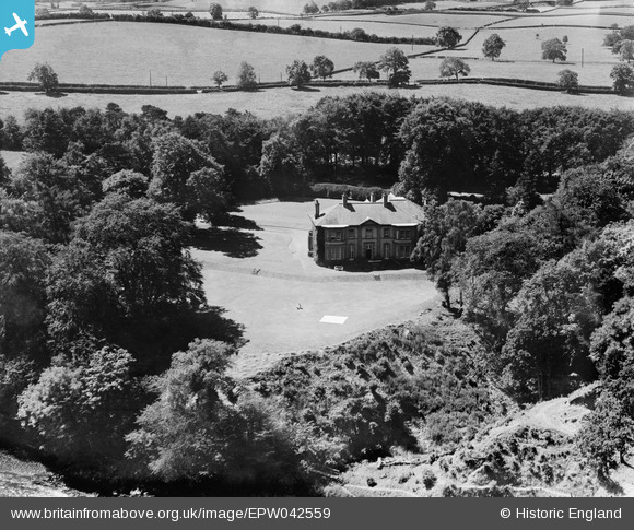
This is 100% definitely "The Holmes" OS GridRef 3587 6314. The River Tweed is in the bottom left of the picture flowing southwards at this point just after it has passed Dryburgh Abbey on the opposite bank. The boundary hedgerow behind "The Holmes" marks the A68 Trunk Road. "The Holmes" is currently used as accommodation for the Scottish Donkey Sanctuary,Mrs.Rosemary Dale, a lifelong enthusiast and breeder of donkeys, decided, in October 2003, to found The Scottish Borders Donkey Sanctuary - a Charity registered in Scotland, Charity No SC034634 , the aims are to provide permanent accommodation for donkeys and mules in need of re-homing whether as a result of rescue from cruelty or neglect or because the current owners could no longer care for them. The Holmes Saint Boswells, Melrose, Roxburghshire TD6 0EL http://www.donkeyheaven.org |
Jim Ross |
Monday 27th of January 2014 11:26:44 AM |
Thank you to eveyone who has contributed in identifing this image. Your information will be forwarded to our Cataloguing team for verification. Many thanks Liz BfA |
Liz Fife-Faulkner |
Monday 27th of January 2014 11:26:44 AM |
a postcard of The Holmes, other elevation |
TomRobin |
Friday 18th of October 2013 05:31:49 PM |
View is looking south west. |
Class31 |
Monday 7th of October 2013 06:51:10 PM |
Think this is a house called The Holmes overlooking the river Tweed.The bridge mentioned is over the old Waverely line. |
martyk |
Monday 7th of October 2013 05:59:22 PM |
I think that you are right on this. The field boundaries fit. |
Class31 |
Monday 7th of October 2013 05:59:22 PM |
This is EPW042558 from the North. The trees hide the other buildings visible in EPW042558. |
BigglesH |
Thursday 18th of July 2013 03:36:29 AM |


