
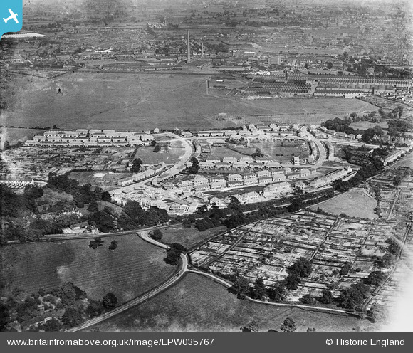
EPW035767 ENGLAND (1931). Housing surrounding Radford Road, Foster Road and the Daimler Motor Car Works, Radford, 1931
© Hawlfraint cyfranwyr OpenStreetMap a thrwyddedwyd gan yr OpenStreetMap Foundation. 2024. Trwyddedir y gartograffeg fel CC BY-SA.
Delweddau cyfagos (3)
EPW035767

EPW035769

EPW035766

Manylion
| Pennawd | [EPW035767] Housing surrounding Radford Road, Foster Road and the Daimler Motor Car Works, Radford, 1931 |
| Cyfeirnod | EPW035767 |
| Dyddiad | 1-July-1931 |
| Dolen | |
| Enw lle | RADFORD |
| Plwyf | |
| Ardal | |
| Gwlad | ENGLAND |
| Dwyreiniad / Gogleddiad | 432411, 281143 |
| Hydred / Lledred | -1.5232891943376, 52.426933950808 |
| Cyfeirnod Grid Cenedlaethol | SP324811 |
Pinnau
 offshoredaze |
Wednesday 18th of December 2013 08:26:47 PM | |
 Class31 |
Tuesday 12th of March 2013 08:51:14 AM | |
Class31 |
Tuesday 12th of March 2013 08:47:59 AM | |
Class31 |
Tuesday 12th of March 2013 08:47:28 AM | |
Class31 |
Tuesday 12th of March 2013 08:46:48 AM | |
Class31 |
Tuesday 12th of March 2013 08:46:24 AM | |
Class31 |
Tuesday 12th of March 2013 08:45:44 AM | |
Class31 |
Tuesday 12th of March 2013 08:45:07 AM | |
 SteveBo |
Monday 11th of March 2013 08:09:06 PM | |
SteveBo |
Monday 11th of March 2013 08:05:04 PM | |
SteveBo |
Monday 11th of March 2013 08:03:23 PM |
Cyfraniadau Grŵp
View looking east. |
Class31 |
Tuesday 12th of March 2013 08:48:39 AM |


