
EPW034210 ENGLAND (1930) [Unlocated]. UNLOCATED
© Hawlfraint cyfranwyr OpenStreetMap a thrwyddedwyd gan yr OpenStreetMap Foundation. 2024. Trwyddedir y gartograffeg fel CC BY-SA.
Delweddau cyfagos (48)
EPW000143

EPW000667

EPW005260

EPW006389
, 1921")
EPW007181

EPW015853

EPW015854

EPW015855

EPW016012

EPW016510

EPW016641

EPW017028

EPW017029

EPW017136

SAW003585

SAW003586

SAW009337

SAW009800

SAW009801

SAW009802

SAW010734

SAW014737

SAW017926

SAW017927

SAW032504

SPW020275

SPW020280

SPW020281

SPW020284

SPW020632

SPW020633

SPW027083

SPW049776

SPW049777

SPW049779

SPW049783

SPW049791

SPW049798

SPW049801

SPW049827

SPW049828

SPW049831

SPW049832

SPW049834

SPW049948

SPW049949

SPW051009

SPW062638

Manylion
| Pennawd | [EPW034210] UNLOCATED |
| Cyfeirnod | EPW034210 |
| Dyddiad | July-1930 |
| Dolen | |
| Enw lle | |
| Plwyf | |
| Ardal | |
| Gwlad | ENGLAND |
| Dwyreiniad / Gogleddiad | 0, 0 |
| Hydred / Lledred | -7.556448482059, 49.766185796754 |
| Cyfeirnod Grid Cenedlaethol | SV000000 |
Pinnau
 Class31 |
Monday 18th of November 2013 11:29:53 PM | |
Class31 |
Monday 18th of November 2013 11:27:43 PM | |
Class31 |
Monday 18th of November 2013 11:26:19 PM | |
Class31 |
Monday 18th of November 2013 11:23:53 PM | |
Class31 |
Monday 18th of November 2013 11:21:50 PM | |
Class31 |
Monday 18th of November 2013 11:19:30 PM | |
Class31 |
Monday 18th of November 2013 11:18:11 PM | |
Class31 |
Monday 18th of November 2013 11:16:01 PM | |
Class31 |
Monday 18th of November 2013 11:14:41 PM | |
Class31 |
Monday 18th of November 2013 11:13:21 PM | |
Class31 |
Monday 18th of November 2013 11:06:19 PM | |
 Maurice |
Tuesday 29th of January 2013 05:59:50 PM | |
Maurice |
Tuesday 29th of January 2013 05:58:39 PM | |
Maurice |
Tuesday 29th of January 2013 05:57:09 PM | |
Maurice |
Tuesday 29th of January 2013 05:55:04 PM | |
Maurice |
Tuesday 29th of January 2013 05:52:49 PM | |
Maurice |
Tuesday 29th of January 2013 05:50:12 PM | |
Bankend |
Class31 |
Monday 18th of November 2013 11:06:56 PM |
Maurice |
Tuesday 29th of January 2013 05:49:20 PM |
Cyfraniadau Grŵp
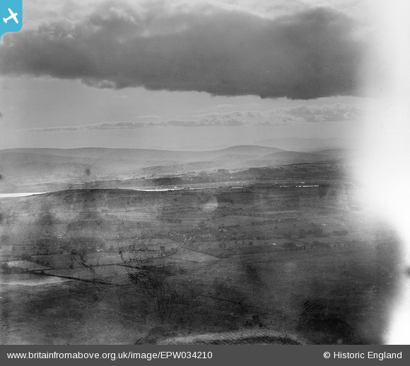
I'm happy that everything fits for Bankend looking west. This is a few miles south east of Dumfries in Scotland and not in the Lake District as we has originally suspected. |
Class31 |
Monday 18th of November 2013 11:34:50 PM |
View is looking west. |
Class31 |
Monday 18th of November 2013 11:09:44 PM |
Eureka I believe that I have located this one, in Scotland at a place called Stank. I shall have to work things up but it looks good initially. If I'm wrong I'll have to eat humble pie. |
Class31 |
Monday 18th of November 2013 11:04:38 PM |
I agree - it feels like one that should have been identified. Forgive my statements of the obvious ... just part of the process of looking properly at the picture. I suspect the clue is in the water across the middle. How straight is it? From the angle it could be quite wide and may even be at high tide and so missing the meanders/mud flats found in an estuary like that of the River Kent near Milnthorpe in the south Lakes. The mountains are too low / too far away for similar straight inlets in Scotland. That there is a gap in the numbers before and after does not help, although the nearest numbers (before) are all Lake District pictures. Oh! for something distinctive like the Langdale Pikes instead of the white at the right. Is this glare from pointing the camera too close to the sun? |
Maurice |
Tuesday 29th of January 2013 06:13:40 PM |
You would think that we could have located this one by now. There is plenty of information in the photo with a coastline and some hills. I have looked at the inlets around the Lake District to no avail. Does anyone have any clues? |
Class31 |
Tuesday 29th of January 2013 02:25:03 PM |


