
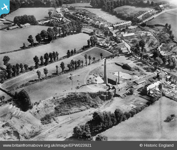
EPW023921 ENGLAND (1928). The Brick and Tile Works, Withycombe Raleigh, 1928
© Hawlfraint cyfranwyr OpenStreetMap a thrwyddedwyd gan yr OpenStreetMap Foundation. 2024. Trwyddedir y gartograffeg fel CC BY-SA.
Manylion
| Pennawd | [EPW023921] The Brick and Tile Works, Withycombe Raleigh, 1928 |
| Cyfeirnod | EPW023921 |
| Dyddiad | September-1928 |
| Dolen | |
| Enw lle | WITHYCOMBE RALEIGH |
| Plwyf | EXMOUTH |
| Ardal | |
| Gwlad | ENGLAND |
| Dwyreiniad / Gogleddiad | 301271, 82163 |
| Hydred / Lledred | -3.3960992739561, 50.630211649494 |
| Cyfeirnod Grid Cenedlaethol | SY013822 |
Pinnau
 Kate Burhouse |
Saturday 23rd of January 2021 02:50:56 AM | |
Kate Burhouse |
Saturday 23rd of January 2021 02:50:36 AM | |
Kate Burhouse |
Saturday 23rd of January 2021 02:49:17 AM | |
Kate Burhouse |
Saturday 23rd of January 2021 02:48:34 AM | |
Kate Burhouse |
Saturday 23rd of January 2021 02:47:32 AM | |
Kate Burhouse |
Saturday 23rd of January 2021 02:45:16 AM | |
Allen T |
Saturday 8th of December 2012 12:06:56 AM | |
MB |
Friday 19th of October 2012 09:44:26 AM | |
MB |
Friday 19th of October 2012 09:42:32 AM | |
Kate Burhouse |
Monday 6th of August 2012 09:37:18 PM | |
 Class31 |
Thursday 2nd of August 2012 10:39:45 PM | |
Class31 |
Thursday 2nd of August 2012 10:38:55 PM | |
Class31 |
Thursday 2nd of August 2012 10:31:08 PM | |
Class31 |
Thursday 2nd of August 2012 10:30:19 PM | |
Class31 |
Thursday 2nd of August 2012 10:29:00 PM | |
Glen37037 |
Monday 2nd of July 2012 03:55:56 PM | |
EastMarple1 |
Saturday 30th of June 2012 08:17:29 AM |
Cyfraniadau Grŵp
Thank you Howard Jones for pointing me in the direction of Exmouth. I can confirm that this photograph is of the Withycombe Village Road area of Exmouth looking in an easterly direction.It is just a short distance east of the photo in EPW023922. It was fun to check the details and gradually confirm that this is the location. The thatched house is still there. The Sleepcentre is an old industrial type building with a public clock on the end wall not visible in the photo. The building to the east of the Sleepcentre still causes a kink in the road. Up St. John's Road there is the terrace on the left and a pair of Suburban semis are on the right at the end of development then. Up Bradham Lane there is now a road leading to the lft between the terraces called Brooklands Road. This is a confirmed identification. |
Class31 |
Wednesday 24th of October 2012 10:56:58 AM |
Great job Class 31, we'll update the catalogue and post the correct location data here in due course. This is another that was recorded as "Harpenden" in the Aerofilms Ltd Register... Yours, Katy Britain from Above Cataloguing Team Leader |
Katy Whitaker |
Wednesday 24th of October 2012 10:56:58 AM |
From adjoining image numbers this is likely to be in Gloucestershire. |
Class31 |
Friday 20th of July 2012 09:42:04 PM |
I take back this comment. I've no idea whether this is in Gloucestershire, or not. |
Class31 |
Friday 20th of July 2012 09:42:04 PM |


