
EPW020029 ENGLAND (1927). West Park and environs, Wolverhampton, 1927
© Hawlfraint cyfranwyr OpenStreetMap a thrwyddedwyd gan yr OpenStreetMap Foundation. 2024. Trwyddedir y gartograffeg fel CC BY-SA.
Delweddau cyfagos (3)
EPW020029

EPW024614

EPW024615

Manylion
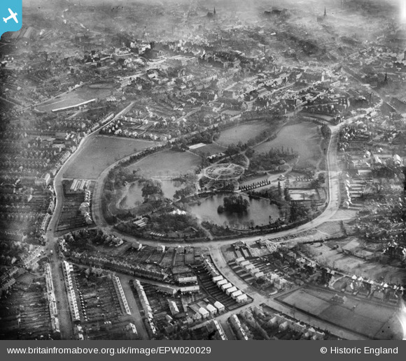
| Pennawd | [EPW020029] West Park and environs, Wolverhampton, 1927 |
| Cyfeirnod | EPW020029 |
| Dyddiad | October-1927 |
| Dolen | |
| Enw lle | WOLVERHAMPTON |
| Plwyf | |
| Ardal | |
| Gwlad | ENGLAND |
| Dwyreiniad / Gogleddiad | 390630, 299139 |
| Hydred / Lledred | -2.13832621496, 52.58961540321 |
| Cyfeirnod Grid Cenedlaethol | SO906991 |
Pinnau
 Dainase |
Sunday 5th of August 2012 09:45:52 PM | |
Where I was married, 1967. |
Janet S |
Wednesday 28th of January 2015 05:48:24 PM |
johnabutt |
Monday 30th of July 2012 08:18:48 PM | |
johnabutt |
Monday 30th of July 2012 08:18:03 PM | |
johnabutt |
Monday 30th of July 2012 08:17:27 PM | |
Correction, it's Molineux Street - minor typo I would guess |
Dainase |
Sunday 5th of August 2012 09:33:47 PM |
johnabutt |
Monday 30th of July 2012 08:16:12 PM | |
johnabutt |
Monday 30th of July 2012 08:15:40 PM | |
kevin_s |
Saturday 7th of July 2012 08:35:31 PM |

Cyfraniadau Grŵp
Lived in Park Avenue, between West Park and Newhampton Road, between 1959 and 1967, 'spitting distance' from Wolves' ground. Could hear the crowd very clearly from our garden. |
Janet S |
Wednesday 28th of January 2015 05:51:13 PM |
 Wolverhampton Wanderers FC, Molineux 1927. |
kevin_s |
Saturday 7th of July 2012 08:41:29 PM |


